Geography Reference
In-Depth Information
123
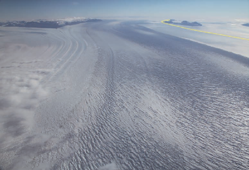
Figure 4.14. Mill Glacier
merges with Beardmore
Glacier in front of the
Dominion Range, left rear.
With the central portion of
Beardmore Glacier heav-
ily crevassed, Shackleton
chose a more snowy route
along its margin. Buckley
Island and Mount Darwin,
the party's last landfalls
before the polar plateau,
bound Beardmore Glacier
in its headreaches, right
rear.
bon that Ferrar had found in the McMurdo area, this was a major deposit and would be
one of the most important geological discoveries of the expedition.
The southern party reached the plateau on December 18. At lunch they camped near
the last point of land in the headreach of the glacier, a solitary peak surrounded by ice,
which they named Mount Darwin (see Fig. 4.14). The rock cropping out there was dif-
ferent from the sandstones on Buckley Island. Shackleton walked over to the outcrop
while lunch was being prepared and found a gray, layered rock that was later identified
as limestone. He collected two samples, which would be the trophies of the expedition,
these pieces of the “southernmost rock,” as rare as moon rock to a later generation.
The day was a struggle over rising blue ice with the men alternating between pull-
ing in harness and relaying with the alpine rope. They carried five weeks' worth of food
and were about three hundred miles out from the pole, or about six hundred miles from
their last depot if they made the distance. By the time they bedded down for the night at
seventy-four hundred feet, they still had not left crevasses behind. Nor would this situa-
tion change for another week. What did turn was the weather, with a succession of hard,
steady winds blowing out of the south directly into their faces.
Excerpts from Shackleton's diary show the hope and frustration that the plateau was
inflicting:
December 19.—Not on the plateau level yet, though to-night 7888ft. up, and still
there is another rise ahead of us.
December 20.—Not up yet, but nearly so.