Geography Reference
In-Depth Information
111
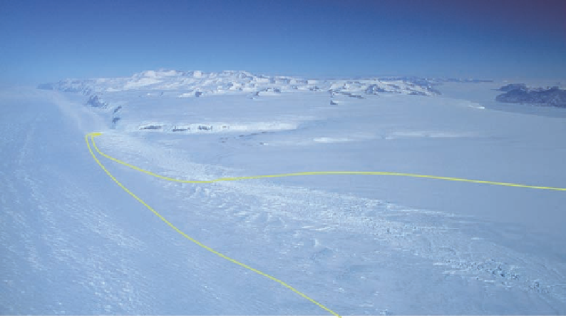
Figure 4.7. Barne's route to
the mouth of Byrd Glacier
failed to reach an outcrop
of rock due to the intense
crevassing where the gla-
cier enters the ice shelf
(see Fig. 4.2).
west. On November 7 they spotted Cape Selborne, and to their right (west) a dark ice-free
shoulder with what they took to be volcanic craters. (This area to the north of the mouth
of Darwin Glacier is actually composed of granite, but the name of the feature remains
Goorkha Craters.)
On November 8, still about fifty miles to the northeast of the mouth of the strait, the
party began to encounter broad undulations in the ice surface spaced about three hun-
dred yards apart, arching out from the opening. Over the next several days these features
grew in amplitude and became increasingly more crevassed. On the 13th Barne thought it
prudent that the party rope up. The undulations now pointed toward the strait, and the
party followed parallel to them, about two miles to the south of a zone of increasingly
disturbed crevassing that extended back to the cape at the mouth of the strait (Fig. 4.7).
The men covered twenty-five miles over the next four days, hauling over and around
increasingly steeper and higher ice ridges. By the evening of November 17 they were
abreast of Cape Selborne to the south and about four miles from rock outcrop at the
northern portal. From the top of a high ice ridge Barne looked west into the strait. Both
the north and south sides of the channel ended in bluVs, and between them was a distinct
horizon of level ice. (The bluV seen on the south side was Mount Tuatara, located about
midway down Byrd Glacier, and the bluV on the north side was the western end of the
Britannia Range [see Fig. 4.2].) Mulock's measurement of the angle of rise of the hori-
zon, a mere one thirtieth of one degree, was so slight that doubt remained as to whether
the horizon was on an inland ice shelf or actually on an ice sheet. Nevertheless, all the
evidence of ice ridges and crevassing led Barne and Mulock to conclude that they were
standing on a glacier that was flowing toward them from the interior.
The last objective then was to collect a piece of the rock from the cliVs to the north of
the glacier. Given the curve of the bluV, Barne could see that moving camp several miles
to the west would bring the outcrop closer, but before the party could move three miles
upstream it was pinned by a blizzard for another thirty-six hours. With improved visibil-