Geography Reference
In-Depth Information
104
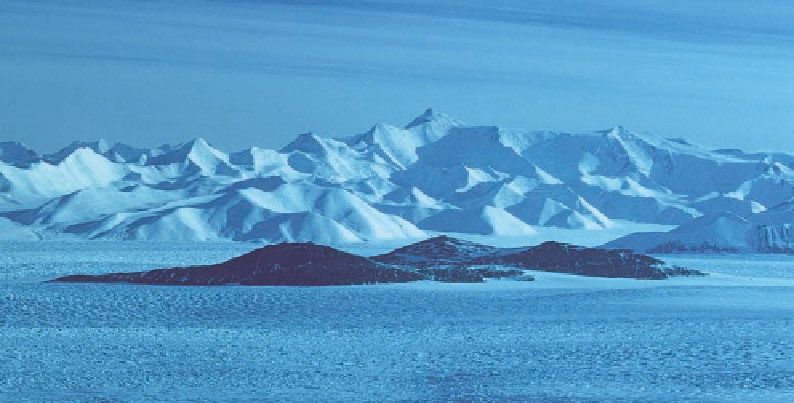
Figure 4.6. A symphony
of ridgelines crescendos
up the northern face to
the summit of Mount
Markham. Nimrod Glacier
flows from right to left
around Kon-Tiki Nunatak,
the dark island in mid-
stream. In this view taken
from the northwest about
forty miles up glacier, the
relief from the edge of the
glacier to the summit of
the massif is more than
eleven thousand feet.
Scott's view would have
been from the northeast
at the mouth of the gla-
cier, but the ridge systems
would have appeared
similarly.
lines rising to over thirteen thousand feet, it pitched most steeply just at the top where it
leveled onto a flat surface with two prominent peaks on its crown. Scott described it as
“a giant among pigmies” and named it Mount Markham, after Clements Markham, the
father of the expedition (Fig. 4.6).
On December 28 the party pulled another six miles south to beyond 82° S, stopping
in the afternoon to survey and sketch the new mountains. From this camp, which was
their farthest south, they planned to continue on skis in order to gain a view up the strait
to see whether the ice continued as a level surface to the horizon or rose in a glacier to the
interior. Was Mount Markham part of an island? Was it separated from the mountains
that they had been surveying for the past month by a glacier? Were the mountains conti-
nental or a volcanic archipelago?
Once again Antarctica held her secrets. On December 29 the party was pinned in its
tent by a blizzard. On the 30th a fog settled in. Scott and Wilson skied out from camp for
a mile or so but turned back for fear of losing their way. On the last day of 1902 the cloud
pulled back, allowing them to ski toward the south, but as they cleared Cape Wilson, the
western reaches of the strait remained shrouded in fog. The snow surface pulled north
around Cape Wilson, with no land visible farther west on the north side of the strait.
On the south side of the strait, the Mount Markham massif ended in a steep bluV (today
known as Inaccessible CliVs). Without the view into the strait, the last hope of answering
the question of the character of the mountains lay in reaching bedrock at Cape Wilson.
However, as the party approached the cape, they encountered another deep rift in the ice,
similar to the one that had turned them back at Cape Selborne, so they failed to collect a
geological specimen that would have provided an answer.
The time had come to turn and head north. They had set the records: the longest as-
sault on either pole, the southernmost advance on Earth, and 250 miles of new mountains
charted, with every expectation that they continued beyond Mount LongstaV into the
heart of the Antarctic. With two weeks' rations and a desperate hope for fair weather, the
men would literally be pulling for their lives.