Global Positioning System Reference
In-Depth Information
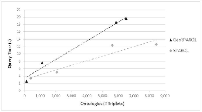
Figure 8 displays graphically the results of Table 1 and Table 2. It shows
a comparison of the results of queries over spatial and non-spatial RDF data.
Each point represents a single ontology, where X axis displays the number
of triplets of each ontology and Y axis the query time.
The graphic shows that a system performing geographic operations
over RDF data needs more time than a system without geographic queries
for the same number of triplets. Furthermore, that difference increases as
the number of triplets increases. Therefore, we can say that spatial reasoning
considerably slows down the SPARQL queries.
Both results show linearity: the more triplets the ontology has, the more
time the query needs. Execution time for SPARQL queries over ontologies
with 1000 triplets or less is acceptable but queries over larger ontologies
are not as effi cient enough for usable smartphone applications. A system
that uses SPARQL queries is not scalable enough for a tourism application
because a district of a city like Barcelona has more than 6000 triplets. Thus,
a system with this architecture cannot achieve the required effi ciency.
Fig. 8.
Comparison of the results performing geographic and non-geographic RDF spatial
queries over ontologies.
Alternative Architecture for End-user Applications
We achieved one of the goals of the paper: to develop a system that integrates
GIS and semantic data using GeoSPARQL queries over ontology data in a
smartphone locally. Nevertheless, the queries in such system are too slow
to be used in an end-user application. Thus, it is necessary an alternative
architecture to get an end-user real life application.
Search WWH ::

Custom Search