Environmental Engineering Reference
In-Depth Information
0
0
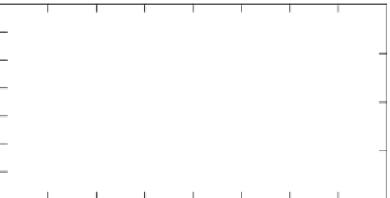
Figure 2.6
Gravity and
groundwater-level relations for
an unconfined aquifer, 1995 to
2002 (after Pool,
2008
). Error
bars represent standard deviation
of gravity survey. Gravity values
without error bars had insufficient
survey data to calculate standard
deviation.
Gravity
20
Depth to water
10
40
60
20
80
100
30
120
Well 2
140
Jan 95
40
Jan 97
Jan 99
Jan 01
Jan 03
maintains the Soil Climate Analysis Network
(SCAN) of sites across the United States where
soil-water content and temperature are meas-
ured hourly at five depths to a maximum of
1 m (
Table 2.1
). These databases are still sparse
in terms of areal coverage, but as more sites
are added, they should become more useful
for water-budget studies. Groundwater levels
for application of Equation (
2.23
) can often be
found in databases maintained by state and fed-
eral agencies. Within the United States, the US
Geological Survey maintains the largest data-
base on real-time and historic groundwater
levels (
Table 2.1
).
to calculate changes in total storage, Δ
S
(Pool
and Eychaner,
1995
):
∆
(2.24)
∆
S
=
1.99
g
whe r e Δ
S
is in millimeters of water and
g
i s g rav-
itational acceleration in μgals. Equation (
2.24
)
is based on an assumption of areally uniform
change in storage. Pool and Eychaner (
1995
)
found standard deviations of gravity changes to
be between 1.6 and 5.9 μgals, equivalent to 3.3
to 11.7 mm of water. Chapman
et al
. (
2008
) esti-
mated the accuracy of gravity measurements at
± 5 μgals in their study.
The temporal gravity method determines
total water storage, as opposed to soil-water con-
tent. The method cannot distinguish between
changes in storage within the unsaturated zone
and saturated zone; this can limit the method's
applicability in some recharge studies. If a well
is near each measurement location, changes
in gravity can be correlated with changes in
groundwater levels. Pool and Schmidt (
1997
)
and Pool (
2008
) used such a correlation to deter-
mine aquifer specific yield. Pool (
2008
) found
reasonable agreement between the measured
depth to the water table and gravity change in
an unconfined aquifer in southeastern Arizona
(
Figure 2.6
). Gravity measurements can be
obtained quickly without the need for a bore-
hole, but gravimeters are relatively expensive.
The method works best when fluctuations in
groundwater levels are in the order of a few
meters or more.
Temporal gravity method for determining
change in subsurface storage
Gravity measurements made from land sur-
face are reliable indicators of total subsurface
mass. Measurements have historically been
used to map spatial variabilit y in mass for pur-
poses of defining geologic structure. Change
over time in the amount of water stored in the
subsurface is usually the dominant factor in
temporal changes in total subsurface mass.
So changes in subsurface mass at a particular
location, as determined with gravity measure-
ments made at different points in time, can
be used to infer changes in subsurface water
storage. Measurements of gravity are made at
specific points on land surface; these points
may lie on a transect or be distributed across
a watershed. Measurements are made at time
intervals that can range from days to months.
After readings have been corrected for tidal
and instrument effects, changes in gravity
between successive readings are then used
2.3.4 Surface flow
Hourly and daily streamflow data for thou-
sands of stream gauges within the United