Environmental Engineering Reference
In-Depth Information
climatic parameters are electronically recorded.
The data are available in real time (via satellite
telemetry) to the general public. The network
is particularly useful for watershed managers
who use the data in streamflow and reservoir
forecasting models to optimize water use and
storage.
Water storage within the subsurface,
S
s u b s
, is
described by the following general equation:
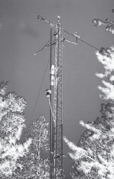
Figure 2.4
Tower to measure evapotranspiration by the
eddy correlation method within a forest and close up of a
sonic anemometer, fine-wire thermocouple, and krypton
hygrometer.
times; Δ
S
> 0 indicates an increase in stor-
age from time
t
1
to time
t
2
. Water storage in
surface-water bodies is usually determined
by measurement of stage and use of a stage-
volume relationship. This relationship can be
determined for a lake, for example, by prepar-
ing a bathymetric map of the lake bottom and
then calculating the volume of water present at
a given stage level. Lake stage can be measured
manually, with staff or wire-weight gauges, or
recorded automatically with float gauges or
pressure transducers.
Water storage in snowpacks has historically
been measured with snow surveys, whereby
manual measurements of snow depth and dens-
ity were made at fixed locations on transects
at specific time intervals through winter and
spring. In recent years, the Natural Resources
Conservation Service (NRCS) has set up the
SNOTEL network of snow monitoring sites
across the western United States (
Table 2.1
).
Snow depth, snow-water equivalent, and other
0
θ
(2.19)
=
∫
base
S
subs
dz
z
where
θ
is volumetric soil-water content, the
upper limit in the integral (0) represents land
surface, z
base
is depth to the base of the aquifer,
and storage due to compression of water and
solids is ignored. Equation (
2.19
) is written for
a soil column of unit surface area, so
S
s u b s
has
units of length (e.g. mm). Storage within indi-
vidual depth intervals of the subsurface can be
represented with Equation (
2.19
) by adjusting
the limits on the integral (
Figure 2.5
). For calcu-
lating
S
uz
, the amount of water stored between
land surface and the zero-flux plane, the equa-
tion becomes:
0
uz
θ
=
∫
ZFP
S
dz
(2.20)
z