Environmental Engineering Reference
In-Depth Information
head (or water content). Application of the unit-
gradient approach requires a measurement of
pressure head (or water content) and a meas-
urement or estimate of hydraulic conductiv-
ity at that pressure head. Drainage estimates
obtained in this manner represent long-term
average values. The unit-gradient assumption
has been invoked in a number of studies (
e.g
.,
Chong
et al
.,
1981
; Stephens and Knowlton,
1986
; and Nolan
et al
.,
2007
).
Initially the unit-gradient assumption was
restricted to uniform material. Chong
et al
.
(
1981
) and Sisson (
1987
) extended the unit-
gradient theory for application to nonuniform,
layered soils. Layers must be thick enough to
permit development of a uniform pressure-
head profile. The flux must be nonzero only in
the vertical direction and uniform throughout
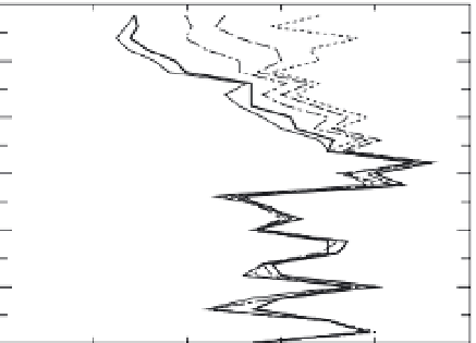
all layers. Data from Roark and Healy (
1998
;
Fig ure 5.11
) support the notion of unit gradients
within heterogeneous sediments. The consider-
able variability in water content with respect to
depth at the site near Roswell, New Mexico, is
due to heterogeneity in soil properties. At any
depth below about 2 m there is little temporal
variability in measured water content. Whether
lateral flow occurred along interfaces of layers
is an important and difficult question to address
in this and other studies.
Example: Sevilleta Grasslands,
New Mexico
Stephens and Knowlton (
1986
) applied the
Darcy method to estimate drainage through
the unsaturated zone at a site in the semiarid
Sevilleta Grasslands, New Mexico. Data were
collected from November 1982 through May
1984 with tensiometers and a neutron probe.
Drainage estimates were made with meas-
ured hydraulic gradients (Equation (
5.13
)) and
with the assumption of a unit hydraulic gra-
dient (Equation (
5.14
)). The site is located on
an old floodplain of the ephemeral Rio Salado;
the soil was a relatively uniform fine sand.
Vegetation was sparse, and the rooting depth
was visually determined to be 1.5 m. The
water table was at a depth of about 6 m. Eight
tensiometers were installed at 0.3 m depth
intervals to a maximum depth of 2.4 m. A
neutron probe access tube was installed
to a depth of 6 m, and readings were taken
biweekly. Unsaturated hydraulic conductivity
was determined in the field with the instant-
aneous profile method.
Measured hydraulic gradients, based on
average monthly pressure heads at depths of
1.53 and 2.44 m, produced annual drainage esti-
mates of 7 and 37 mm, or 4 and 20%, respectively,
of annual precipitation of 179 mm. Invoking
the unit-gradient assumption and using mean
monthly water contents, annual drainage was
estimated to be 97 mm at the 1.22-m depth and
37 mm at the 1.53-m depth, or 54 and 20% of
average annual precipitation, respectively.
The wide scatter in drainage estimates
underscores the previously mentioned con-
cerns with the Darcy method. According to
the authors, the most likely source of estima-
tion error is the uncertainty in the unsaturated
hydraulic conductivity. The instantaneous pro-
file method generated hydraulic conductivities
primarily in the wet range of soil conditions.
Most of the calculated drainage occurred under
drier conditions; hence, the generated curve
had to be extrapolated beyond the measured
points. Instrumentation problems were also a
concern. Tensiometers did not always operate
properly because of leaks. Slight inaccuracies
in measured water contents or pressure heads
0
1
2
3
May 09
May 10
May 11
May 15
Jun 05
4
5
6
0
0.1
0.2
0.3
0.4
0.5
Water content (m
3
/m
3
)
Figure 5.11
Water-content profiles for 5 days in 1996
in a field near Roswell, New Mexico (after Roark and
Healy,
1998
). The field was irrigated after the May 9
measurement.