Graphics Programs Reference
In-Depth Information
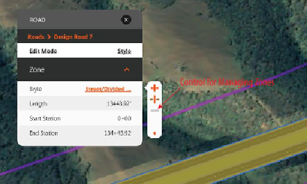
removing zones (see
Figure 2-5
). A right-click
menu also provides the same functions.
Figure 2-5:
The Road asset card shown with
the control for managing zones
Editing Roads Graphically
In this section you'll study the use of the
Geometry mode of the Road asset card. This is
the edit mode that enables the editing gizmos as
well as some specialized context menu
commands. It also displays information about
the road such as its function, design speed, and
applied standards, as well as geometric
properties such as overall length, elevation
range, and grade range. The only values that
can be edited in this mode are the name of the
road and the note beneath it.
Figure 2-6
shows
the Road asset card in Geometry mode.
Search WWH ::

Custom Search