Graphics Programs Reference
In-Depth Information
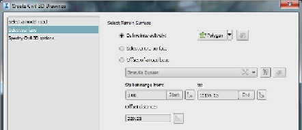
Figure 3-24:
The Select Surface view of the
Create Civil 3D Drawings dialog
There are three options:
Define Interactively
This is a selection
method you are likely already familiar with
because it appears elsewhere in InfraWorks.
With this option you can sketch an area by
polygon, rectangle, or bounding box.
Select Entire Surface
Just like it sounds,
this option will choose the entire surface
represented by your model extent. This
choice is not recommended for most
models, especially large models. It could
cause the export process to take a long time
and could generate a large amount of
surface data in areas that you don't need.
Offset Of A Road Base
With this option,
you define the surface area by offsetting the
centerline of your design road (see
Figure
3-25
). You can define a station range and
offset distance. You can even click the Edit
Area Of Interest button to make
Search WWH ::

Custom Search