Geoscience Reference
In-Depth Information
(a)
a
38°
b
NEVADA
Owens
Owens
River
Owens
River
River
c
g
36°
f
d
e
h
120°
116°
Late Pleistocene lakes
Modern state boundaries
Overflows
a
b
c
Russell
Adobe
Owens
d
e
f
China
Searles
Panamint
g
h
Manly
Mojave
(b)
Sierra Nevada
(4400m)
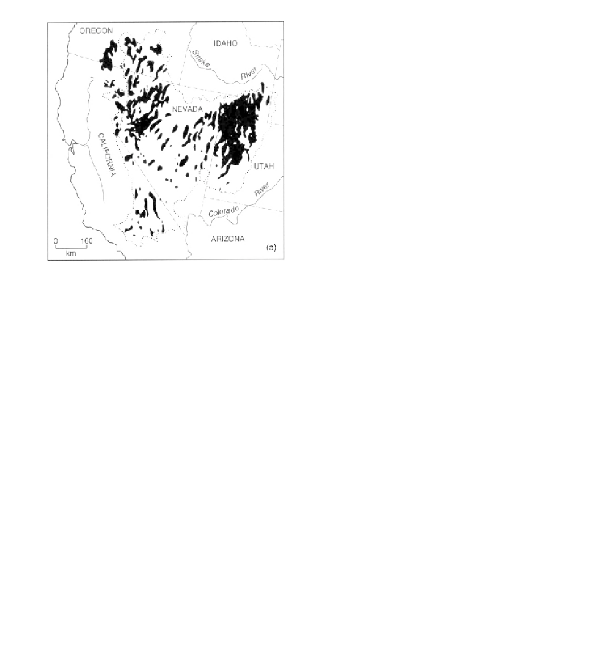
Figure 4.3
Distribution of lake basins, at their maximum ex-
tent, in the Great Basin.
c
Death
Valley
e
d
1081m
f
g
657m
493m
317m
the individual basins possessed water bodies during the
Late Quaternary - and fans are common at the mountain
front-basin interface.
The large number of lake basins does not mean lakes
were small (Figure 4.3). Sediments in and shorelines
around basins have provided important data for re-
constructing regional environmental change in the Late
Quaternary through the direct contribution of increased
precipitation, versus the role, for example, of glacial
meltwater, in feeding high lakes (e.g. Li, Lowenstein and
Blackburn, 1996). During wetter phases, individual lakes
coalesced where topography facilitated this or lost their
closed status and flowed one into another (Figure 4.4).
The largest, Lake Bonneville, covered almost 52 000 km
2
and attained a maximum depth of 370 m (Grayson, 1993).
Its sump is today's Great Salt Lake.
The active tectonics that created the basin-and-range
terrain have continued to impact markedly and obviously
on the operation of geomorphological processes in the
Great Basin. Alluvial fans (see Chapter 13) are a very
significant landscape feature of this desert region. Not
only are fans commonly trenched due to persistent uplift,
but their very presence is at least in part due to the highly
effective weathering and erosional environment that uplift
creates in the mountain zones. In many contexts, erosive
pediments are a significant feature of the zone between
-86m
Figure 4.4
(a) Death Valley, California, has a mean annual
precipitation of only 41 mm. Note evaporite deposits in the
foreground and alluvial fan in the background. (b) and (c) Dur-
ing the Late Pleistocene the valley was occupied by Lake Manly,
which at its greatest was 183 m deep and 1600 km in area.
This was one of a chain of lakes, linked by overspill channels,
supplied by moisture from the Sierra Nevada via the Owens
River. (b) and (c) These are respectively based on diagrams in
Flint (1971) and Smith and Street-Perrott (1983).
4.4
Summary issues
Although the explanation above has focused on two desert
regions to exemplify the broad characteristics of the ex-
treme ends of dryland landscapes, other case studies could
have illustrated the points under consideration equally
well. Nor do these examples illustrate the full diversity
that occurs with the global arid zone. Indeed, it could
be argued that each dryland region is distinctive in its
own right: different interplays between erosional and de-
positional processes, and the balance between tectonic,
sediment and climatic controls (past and present), are the
broad determinants of the geomorphological characteris-