Geoscience Reference
In-Depth Information
6
1
2
Subaqueous
evaporites
Water table
5
5
5
5
3
Bedrock
4
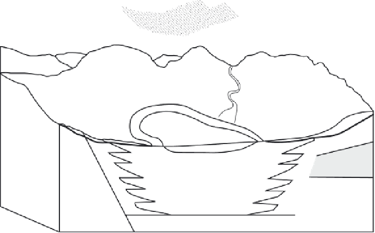
Figure 15.5
Sources of groundwater to a playa basin: 1, channelled flow in permanent or ephemeral streams; 2, unrestricted
overland flow (sheet wash); 3, hydrothermal fluids from a deep source (may occur as a seep or spring or directly mix into the
groundwater); 4, connate or formation water derived from when the formation was deposited; 5, meteoric groundwater derived
within (hydrologically closed) or outside (throughflow) the immediate basin; 6, direct precipitation on to the playa surface or
surrounding catchment (after Rosen, 1994).
15.2.1
Inflow and water balance modelling
individual basin settings, marginal sedimentation can
be achieved by the activity of ephemeral rivers, allu-
vial fans, sand seas or, more rarely, by mass movement
processes.
The dominant sediment types encountered within the
basin are fine sediments brought in by surface flow or
aeolian action, organic materials and evaporite miner-
als. The main ions encountered are SiO
2
,Ca
2
+
,Mg
2
+
,
K
+
,Na
+
,Cl
−
,HCO
3
−
,CO
3
−
and SO
4
−
, which are de-
rived from both the surface and groundwater catchments.
Hardie, Smoot and Eugster (1978) note that weathering
reactions and catchment lithology are the first determi-
nants of the types of salts precipitated within the basin,
although airborne salts may be important in coastal lo-
cations (Jack, 1921; Eckardt and Spiro, 1999) and have,
in the long term, contributed to inland playas as well
(Chivas
et al.
, 1991; Jones, Hanor and Evans, 1994). Pre-
cipitation, in turn, is controlled by salt composition and
concentration and the relative influence of the surface
and groundwater regimes (Rosen, 1994) (Figure 15.5).
Given the range of solute sources, transport mechanisms
and evaporative regimes in playa basins, it is important
to note the geochemical diversity of the evaporite de-
posits that can accumulate within any one basin over
The hydrological regime affects pan development and
morphology in two ways: first, in relation to external
factors such as climate and catchment; second, in the
relationship between the surface water and groundwa-
ter inputs within the basin. Bowler (1986) addresses this
first control in his model of a six-stage hydrological se-
quence for closed basins in Australia. The stages range
from a lake with permanent surface water at one end
of the continuum to an ephemeral terminal sink totally
controlled by groundwater at the other (Figure 15.6). A
disequilibrium index,
eL
, calculated from hydrological
and climatic data, was also used to relate present condi-
tions in a basin to those necessary to maintain a steady-
state water cover, with values ranging from 0 in presently
perennial basins to
1000 for those currently in the driest
locales. While the results, in ignoring many of the other
basin variables, are not universally applicable, they serve
to emphasise the difference between surface water and
groundwater processes, both in terms of the nature of the
waters and sedimentation and in their interrelationships,
particularly within the flooding-desiccation cycle.
Rosen
−