Geoscience Reference
In-Depth Information
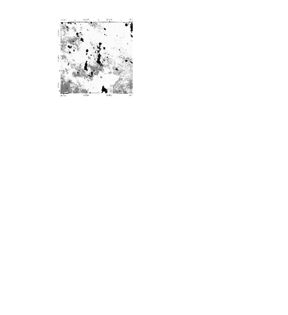
(a)
(b)
20°30'E
20°35'E
20°40'E
20°45'E
20°30'E
20°35'E
20°40'E
20°45'E
25°50'S
25°50'S
25°55'S
25°55'S
26°0'S
26°0'S
2
0 km
2
0 km
Figure 1.5
Interpreted Landsat TM images from part of the southwest Kalahari, Northern Cape, South Africa. These classified
images are of the exact same area but from (a) September 1984 and (b) July 1993. They show how dryland vegetation cover
can vary in response to precipitation change. In both images, black areas are river valleys, pan depressions or cloud cover: the
remainder is typical Kalahari sand desert. In image (a) classification shows in dark grey areas with less than 14 % vegetation cover
on the ground. This image covers the end of a period of several years of deep drought, whereas image (b) is from the dry season
of a year in a period of normal (arid, c. 200 mm p.a.) rainfall. The
<
14 % cover area in 1984 was 10 % of the total scene, reduced
to less than 3 % in 1993. The enhanced area, given sandy sediments, in 1984 was subject to increased wind erosion hazard, while
the remaining 3 % in the 1993 image is the result of grazing pressure, mainly in association with livestock water points.
these, in the context of the arid zone, that this topic is
addressed.
Section One
sets the physical framework for consider-
ing arid zone geomorphology considering the large-scale
controls that shape drylands. The tectonic characteristics
and settings of drylands are examined in Chapter 2, with
the role of climate change, especially during the Quater-
nary period of geological time, in leaving environmental
legacies investigated in Chapter 3. Chapter 4 addresses the
question of how variable drylands are around the world,
and on what basis any variability occurs. As environmen-
tal systems in extraterrestrial locations, notably Mars, are
being explored systematically, many contributions to arid
zone geomorphology on Earth are being made. This wider
context is pursued in the final chapter of this section.
The themes and issues examined in Section One are then
utilised as necessary in the thematic sections that then fol-
low, all of which consider both processes and landforms.
Section Two
considers land surface processes and char-
acteristics. It is often noted that the relatively vegetation-
free surfaces of drylands allow bedrock and material char-
acteristics to exert a greater direct (but not necessarily
overriding or all-determining) influence on geomorphic
development than in other environments. The six chapters
in this section each consider a major aspect of surface
conditions and processes. The processes and controls on
rock weathering are discussed in Chapter 6, and soil sys-
tems, including the role of crusting, in Chapter 7. Chapter
1.10
Organisation of this topic
There are many ways in which a topic covering the geo-
morphology of arid environments could be organised. In
this case, the main chapters have been divided among six
sections for convenience, each devoted to a major theme
in arid zone geomorphology.
Table 1.6
Some geomorphological hazards.
Materials
hazards
Water hazards
Wind hazards
Flooding
following
rainfall
Dust storms
Landscales in
mountainous
areas
Subsidence after
water
extraction
Dune
encroachment
Desiccation
contraction of
sediments
Gully
development
Dune
reactivation
Salt weathering
Soil erosion
Soil erosion