Geography Reference
In-Depth Information
1
1
1
1
1
2
2
1
1
2
2
3
3
Strahler Ordering
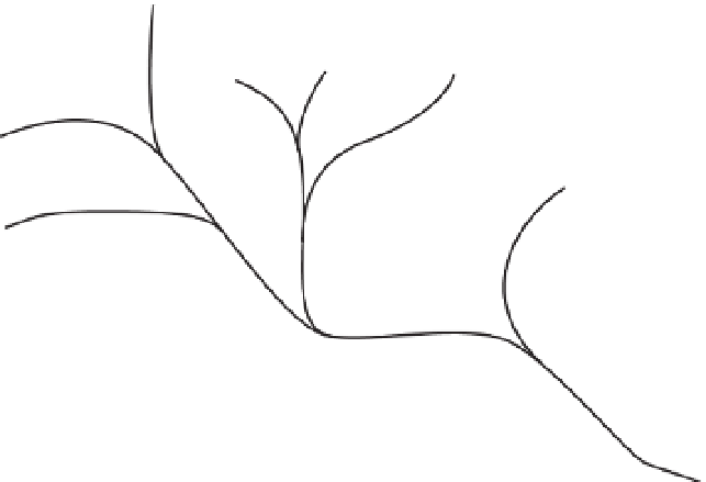
FIGURE 8-34 The Strahler method of stream ordering
Two ways of determining stream order number have been devised (one by A. N. Strahler in 1957 and the
other by R. L. Shreve in 1966), as discussed below. In both methods, the smallest originating streams are
numbered 1, from the source of the stream continuing up to the first intersection.
In the Strahler method, when (any number of) streams of the
same order
merge at a point, the downhill
stream takes on an order number that is the original stream order number plus 1. For example, if a stream
of order 3 merges with another stream of order 3, the resulting stream is order 4.
In any other case of stream merging, the order number of the downhill stream retains the order number
of the larger uphill stream. So, if a stream of order 3 is joined by a stream of order 2, the resulting stream
is still of order 3. Figure 8-34 illustrates the Strahler method.
When two streams merge according to the Shreve method, the order numbers of the uphill streams are
added together to produce the order value of the downhill stream. So, when merged, two streams of
order 3 produce a stream of order 6. An order 3 stream joined by an order 2 stream produces an order 5
stream. Figure 8-35 illustrates Shreve ordering.
To generate stream orders in ArcGIS, you use the Stream Order tool, which allows you to choose either
the Strahler or Shreve method.
Watersheds and Pour Points
A basin is an area that drains water and other substances carried by water to a common outlet as
concentrated drainage. Other common terms for a basin are watershed, catchment, and contributing area.
The contributing area is normally defined as the total area contributing water flow to a given outlet, also
called a pour point.
A delineation of these areas is the output of the Basin tool calculation. The geographic line between two
basins is referred to as a basin boundary or drainage divide. Such a line, as you might imagine, runs
along ridge tops and other lines of relatively higher elevation.


Search WWH ::

Custom Search