Geography Reference
In-Depth Information
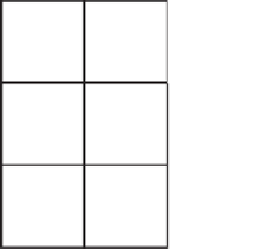
6
7
8
5
1
4
3
2
FIGURE 8-20 Direction
code for the next cell in the
path
Because the path generated by cost distance goes from cell center to cell center, each cell in the direction
raster contains information that indicates to which of the eight neighbors the path goes next. This
information is coded according to Figure 8-20.
Or, in words:
1 means the next cell in the path is to the east (90 degrees).
2 means the next cell in the path is to the southeast (135 degrees).
3 means the next cell in the path is to the south (180 degrees).
4 means the next cell in the path is to the southwest (225 degrees).
5 means the next cell in the path is to the west (270 degrees).
6 means the next cell in the path is to the northwest (315 degrees).
7 means the next cell in the path is to the north (360 degrees).
8 means the next cell in the path is to the northeast (45 degrees).
A Major Application of Raster Processing: Hydrology
Because of the regular nature of the areal unit in raster processing, a number of applications, such as
a simulation of a forest fire or an oil spill, are made much simpler. Hydrologic modeling is one such
application, so we look at it in some detail, both for its own sake and because it illustrates the power of
spatial analyst. An important proviso: If you want to do serious hydrologic investigations, you should
use packages designed for the purpose, including those provided as separate software by Esri.
You may not have thought a lot about how water flows over the surface of the Earth, or how to simulate
it with a computer, so let's explore the following:
The fundamental elements of hydrologic modeling and analysis
❏
How to determine the direction of water flow from cells in a study area
❏


Search WWH ::

Custom Search