Geography Reference
In-Depth Information
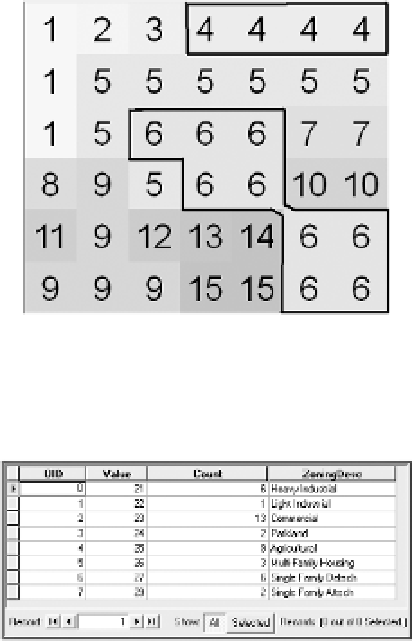
FIGURE 8-6 Type VIII Regions of
Basic_Raster (neighbors sharing
sides and corners)
FIGURE 8-7 A raster attribute table
enhanced with an additional column
Rasters with Floating-Point Values
Rasters with floating-point cell values are used to store what is called continuous data. Such data may
also be referred to as nondiscrete data, field data, or surface data. The numbers are stored in a format
that allows many significant digits and great range. A given cell may well have a different value in it than
any other cell in the raster. The concept of a zone does not apply, since most of the zones would probably
consist of a single cell and, therefore, usually, no value attribute table. The values in a floating-point raster
usually represent magnitude, elevation, distance, or relationships of cells to other nearby cells in that or
some other raster. A major use for floating-point rasters is to represent surfaces, such as elevation of the
Earth's surface, or surfaces derived from point data such as rainfall over an area. The word “continuous”
is something of a misnomer. There are abrupt changes in Values at the boundaries of cells. The amount
of change at boundaries can be reduced by using more and more cells—that is, higher resolution—but, at
the conceptual level, the lumpiness of the surface remains. See Chapter 6 for a discussion of continuous
and discrete phenomena.
What Is Raster Storage and Processing Good For?
To start with, rasters can be used to solve the same sorts of problems that vectors can. As computers
have become more powerful (bigger memories, higher speeds, lower costs, improved compression
techniques), rasters are rivaling their vector cousins in solving problems like the Wildcat Boat facility


Search WWH ::

Custom Search