Geography Reference
In-Depth Information
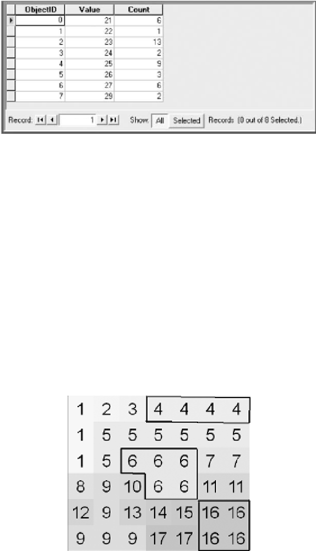
FIGURE 8-3 Basic_Raster Value Attribute Table (VAT)
The raster shown Figure 8-2, which we will call Basic_Raster, would have a VAT as shown in Figure 8-3. It
indicates, for example, that Zone 21 consists of six cells. Figure 8-2 shows you that the cells with value 21
are not all connected.
There is a term for sets of cells that have the same value (i.e., are members of the same zone) and that
are
connected. That term is “region.”
5
Regions are subsets of zones: They are connected cells of the same
value. With a command called RegionGroup, the cells in each region can be identified. Regions can be
defined in two different ways. I will define a region of Type IV as one that consists of all the cells that
have the same value and are connected by sharing a side; thus, each cell may have four (IV) neighbors.
A region of Type VIII consists of cells that all have the same value and are connected by sharing a side
or
touching at a corner
; thus, each cell may have eight (VIII) neighbors. (There are only these two types.)
Figure 8-4 shows the regions of type IV. Note from 8-2 that Zone 23 has 13 cells. If RegionGroup is
applied to Basic_Raster, and Type IV regions are asked for, the result looks like Figure 8-4 with attribute
table shown in Figure 8-5. Note that the 13 cells of Zone 23 are divided into three groups; the region
numbers are 4, 6, and 16. The Link number tells the cell Value in the original raster.
FIGURE 8-4 Type IV Regions of
Basic_Raster (neighbors sharing sides
but not corners)
5
If you needed proof that raster models and vector models grew up independently, you have only to look at the defini-
tions of region. For vector coverages, a region is defined as “a coverage feature class that can represent a single area
feature as more than one polygon.” Those polygons could be, and frequently are, disconnected.


Search WWH ::

Custom Search