Geography Reference
In-Depth Information
Two-Dimensional Entities in a Two-Dimensional Field: Polygons
Let's look quasi-philosophically at definitions of plane areas and the lines that define them. Lines define
polygons, but sometimes it's not really clear what is meant by some basic terms.
A common definition: A polygon is a closed plane figure bounded by three or more line segments. This
implies that the area inside the segments is included and could be calculated. For example, a standard
definition of a triangle is that it is a three-sided polygon. But what is a triangle? It is the metal frame of a
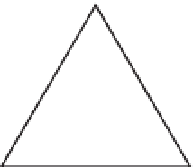
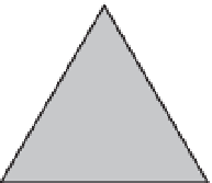
truss or the sail of a boat? Which of the two figures below would you consider a triangle?
Probably you would say both, although one is three line segments while the other is an area. If the one on
the right, which is an area, is called a triangle, then what is the figure on the left to be called?
Also one could ask: what is a circle? Is it the curvilinear line? Or is it the plane figure like a coin? That is,
is it the locus of points at a distance “d” from a single point “c” (the center), or is it the locus of points at a
distance “d” or less than “d” from the single point “c.” “Circle” is used in English both ways.
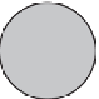
Look at these figures—which do you consider the circle?
You still might say both, but probably the one on the left fits the usual definition. The one on the right, with the
area included, is more properly called a disk (or disc). On the other hand, we speak of the “area of a circle” and
have a formula for it. But based on the definition of a circle shouldn't we refer to “the area within a circle”?
With ArcGIS we can make a definitive statement. A figure is a polygon if it has an associated area. A
sequence of line segments, although it may be closed, is not considered a polygon. That being said,
be aware that the ArcGIS geodatabase definition of a polygon completely butchers the mathematical
definition of a polygon. The following are considered polygons:


Search WWH ::

Custom Search