Geography Reference
In-Depth Information
A computer, on the other hand, is finite (small, really) and discrete to a fault (made up, at its most
fundamental level, of things, i.e., bits, that either are or aren't, i.e., 1s or 0s—there is no middle
ground).
So the question is this: How can we extract significance from the complex, virtually infinite,
multidimensional natural and human-made environment and, using only numbers, letters, and
patterns of bits, make the computer form a “map” that can be easily analyzed and compared with
features that make up the environment we are interested in. Put another way, we need to find a way of
structuring the geographic data in the computer's memory so that we can derive answers to queries we
might make.
Structures for Spatial Data
What are the principles, fields, ideas, tools, and techniques that are in play in the development of spatial
data structure? There are several:
Geometry.
A branch of mathematics that deals with the measurement, properties, and relationships
of points, lines, angles, surfaces, and solids. With plane geometry we can define a set of polygonal
areas with line segments. We can overlay one polygonal set with another, using geometry to
calculate where line segments intersect and make new polygons.
Topology.
Loosely, a branch of mathematics concerned with the properties of geometric
configurations that are
unaltered
when positions of points, lines, and surfaces are altered. (Classic
joke: A topologist is a mathematician who can't tell the difference between a coffee mug and a
doughnut [since each is a solid objects with a single hole].)
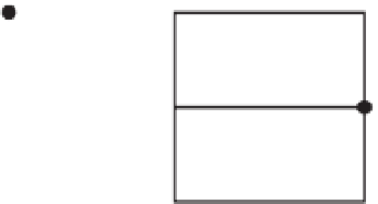
Look at the three plane figures composed of lines connected to nodes (see Figure 4-1). Nodes are
shown by heavy dots. While configuration “A” and configuration “B” appear to have a lot in
common cosmetically, configuration “A” and “C” are topologically identical and Configuration “B”
is different from both. “A” and “C” have the same number of lines and nodes as each other, and you
can find equivalences in the connections of the nodes in those two configurations. However, you
cannot “map” “B” on to either “A” or “C”. If you don't see this, assign letters to the nodes and
numbers to the lines in all three. Make a table for “A,” “B,” and “C,” showing what node is
connected to what node with what line.
Idealization.
Easily manipulated symbols are substituted for actual, three-dimensional real-world
objects. All physical objects exist (over time) in three-dimensional space. If the object's measure in
A
B
C
FIGURE 4-1


Search WWH ::

Custom Search