Information Technology Reference
In-Depth Information
over-farmed river, we can rarely see immediate physical evidence of our impact
directly. Seeing that there are no longer trees requires knowing that there once
were forests.
When we map our world we are mapping it for ourselves: to navigate it,
control it and understand it as it relates to us.
3
The objective view of the earth,
the blue-green blob seen from the moon, tells us nothing of the world of people,
who might as well not be there for all we can see. To see ourselves on this planet
we had to create first the abstract spaces upon which our paths could be drawn
(Figure 3.3).
Early maps of the world were centred on the religious capitals, the land
was magnified where most people were known to live and most detail could
be drawn.
4
There were maps of kingdoms and empires, spaces that contained
land - the land that contained people. The world was flat, as you could not sail
around it (at least not around the back). Rivers were drawn as wide barriers,
mountains enlarged as impassable obstacles. Today roads are drawn far wider
than their real width.
Map projections were first deliberately devised to aid navigation; straight
lines on the map maintained their compass orientation (Box 3.1). The shape of
the world changed again, and suddenly it was full of oceans and seas where once
the land had crowded out the space for water so as to fit in the names of places
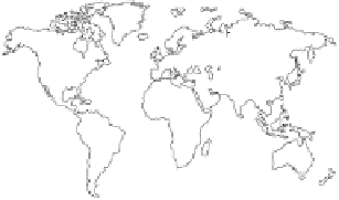
Box 3.1
The Mercator projection
The Mercator Projection maintains all
compass directions as straight lines and
was, thus, extremely useful in an age
of maritime navigation. It distorts areas
considerably. Greenland is very much
magnified while Africa is relatively
shrunk. The shape of the areas is also
altered, but this is always inevitable, to
some extent, in flat representations of
the surface of the Earth.
It is surprising that, centuries after its inception, this image (and other
images like it) should still present the accepted view of the world, a series
of lines, dividing land from water, which mediaeval explorers used to chart
their way over the oceans to distant coasts.
simple mechanical accuracy in maps is not enough. Map makers should provide psy-
chologic, or call it aesthetic, accuracy as well
3
'
...
. [a conventional] map could not be much more
deceiving than it is even if a conscious effort were made to make it so' (Williams, 1976, p. 216).
4
'In ancient times and the middle ages, maps were highly subjective. No impersonal codes and
conventions. No uniform scale, orientation or even distances' (Hagen, 1982, p. 326).
...


Search WWH ::

Custom Search