Geography Reference
In-Depth Information
Fig. 5.2
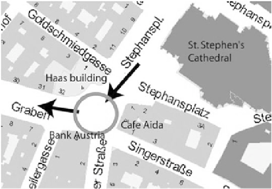
Example of a wayfinding situation where a reference to a landmark may be used to
s
D
w
v
is
s
v
is
C
w
sem
s
sem
C
w
str
s
str
(5.1)
And since salience reflects local differences between geographic objects, i.e., one
object being noticeably different in one or several of the salience properties, the
final step is to calculate these differences, for example, by employing maximum or
minimum operations, which will result in the geographic object with the highest (or
lowest) salience value in a given local configuration of objects.
model may be applied to determining landmark salience. Consider the situation
There are three buildings that are of interest at the marked intersection: Café
Aida, Bank Austria and the Haas building. Table
5.2
shows the values of each
property for the Haas building. The table also indicates which of the properties
are significant and, thus, need to be taken into account for calculating landmark
mining their landmark salience works accordingly, which leaves us with a salience
score of 1:8 for the Haas building, 1:2 for Bank Austria, and 0:9 for Café Aida.
Applying a maximum operation results in the Haas building as being the most
salient geographic object at the intersection. It seems to be the most recognizable
one in terms of landmark identification. We will see below that this does not
automatically mean it is always the best landmark to use when communicating about
this intersection.
extension. The underlying assumption of advance visibility is that landmarks that
Search WWH ::

Custom Search