Geoscience Reference
In-Depth Information
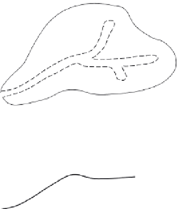
Fig. 11.4 Schematic plan view of a second-order
catchment illustrating the extent of the
variable source areas (inside the dashed line)
on which overland flow takes place: (a) under
drought flow conditions; (b) and (c) after the
onset of precipitation. The stream channels
and the saturated areas near the stream
channels expand as the precipitation
continues.
(a)
(b)
(c)
For instance, as early as 1961, US Forest Service hydrologists (Hewlett, 1974; Hewlett
and Hibbert, 1967) reported that in forested hilly catchments in the Coweeta section in
the southern Appalachians of North Carolina, the streamflow hydrograph rises as a result
of precipitation on the channel itself and as a result of the expansion of these saturated
areas in its immediate vicinity. The expanding and shrinking areas are often referred
to as
variable source areas
(see Figure 11.4). On the basisofhill slope measurements
in Vermont, Dunne and Black (1970a; b) also concluded that the stormflow originated
from surface flow on limited areas along the stream channel. However, their interpretation
of the mechanism was that this surface runoff was not fed significantly by subsurface
outflow, but resulted mostly from rainfall on the expanding streamside areas; the role of
the subsurface flow was mainly to control the expansion and subsequent contraction of
the source areas.
But saturation excess overland flow does not always occur in the immediate vicinity of
the stream. In a tropical rainforest in northeast Queensland, Bonnell and Gilmour (1978)
and Elsenbeer
et al
. (1995a) observed that high intensity rainfalls generate widespread
perched water table conditions close to the soil surface, which emerge easily; this results
in saturation excess overland flow accompanied by subsurface flow within the top 20 cm.
Evidence for this was taken to be the presence of pre-event water in the streamflow, that is