Geoscience Reference
In-Depth Information
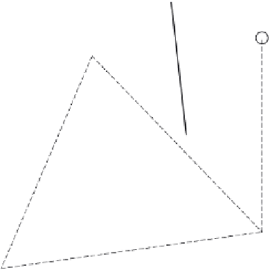
Fig. 3.11 Sketch illustrating the
application of the
Thiessen polygon method
to estimate the subareas
A
i
assigned to the
precipitation gages on the
map of a catchment. The
subareas are bounded by
the boundaries of the
catchment and by the
lines drawn midway
between the stations. The
locations of the stations
are indicated by the
numbered circles.
4
3
A
3
A
4
A
1
2
A
2
1
uniformly over the rising terrain, the resulting precipitation can be expected to be of the
stratiform type. However, in situations when the incoming air is already unstable, much
higher convective type precipitation intensities develop; this may be especially the case
with irregular topography and uneven surface heating, when some parts of the air mass
have higher temperatures than others at the same height, so that locally the convection
mechanisms, as illustrated in Figure 2.4, come into play.
3.3
PRECIPITATION DISTRIBUTION ON THE GROUND
3.3.1
Spatial distribution
Areal average from precipitation gages
In hydrologic analyses at the basin- or catchment-scale, the input is of necessity taken
as the average precipitation over the entire area. Different weighting methods have been
used in the past to estimate this average from the available precipitation gage network.
When no other information is available, the only possible method is to take the regular
average value, i.e. the
arithmetic mean
, with equal weights assigned to all gage stations.
When the locations of the stations are known on a map, the
Thiessen polygon
method
(Thiessen, 1911) has been commonly used. Here each gage represents a subarea,
A
i
,
which is determined as the area bounded by the perpendicular bisectrices between the
station and those surrounding it (see Figure 3.11); the spatial average is calculated by
weighting the individual stations with their representative area, namely
n
1
A
P
=
A
i
P
i
(3.1)
i
=
1