Geoscience Reference
In-Depth Information
in which he proposed the method of triangulation. He also worked on optics but did not
publish in the field. His discovery of the sine law of refraction became known when a later
prominent scientist, Christiaan Huygens, published it.
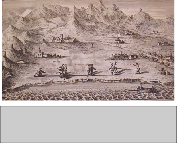
Snell had proposed the technique of triangulation as a way to measure the relative
locations of points on the surface of the Earth (Smith 1986). The method, which is
still the standard one, starts by the surveyors measuring a reference line between
stakes on a flat plain using standard sized sticks or chains (
Fig. 7
). A third stake is
placed somewhere else on the plain at a significant location. From each end of the
line, a surveyor sights the stake at the other end as well as the third stake, measuring
the angle between with a
theodolite
. The third stake is located relative to the other
two by trigonometry of the triangle. From the reference points the surveyor can also
sight natural vertical features in the landscape. Particularly crucial reference points
can be made permanent by erecting pillars made of stone, sharpened like a pyramid
to a point at the top to give the greatest potential accuracy to measurements of their
position. All these features can be located relative to the others building a chain of
triangles across the country - hence the term “triangulation”.
Naturally, hill-top locations are important in the execution of the triangulation
(
Fig. 8
). They are clearly visible from long distances and, on the contrary, from
them large areas of the country can be seen below. The reference points that the
early surveyors used on hills and mountains included not only chapels, windmills,
thatched cottages, hunting lodges, ruined buildings and signals (iron basket-like
Fig. 7
The first stage in triangulation is to lay out a baseline on a plain. Surveyors use meas-
uring sticks, laying them down alongside a straight line marked out by a rope or chain staked
out on the ground. Here each measuring stick seems to be 4 metres long and is thus a two toise
standard. All around the plain are suitable triangulation points - church steeples, towers, wind-
mills, mountain tops, trees and the like - which will be sighted from the ends of the baseline.
César-François Cassini de Thury (1744)