Environmental Engineering Reference
In-Depth Information
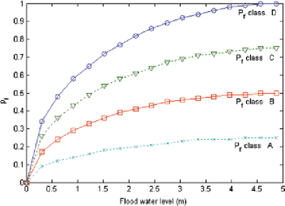
Fig. 16.4
Evolution of damage risk Pf
f
depending on the flood water level
Risks and Decision Making
The Geographic Information System (GIS) maps are adequate tools for mapping
risk, hazard and expected socio-economic losses at local or large scales, (Fig.
16.5
).
They are very helpful when making decisions or analyzing resilience in different
flooding scenarios. Adequate solutions can actually be proposed to improve resil-
ience and provide a better capacity to urban systems: building surrounding barriers,
dikes, and dams (Mebarki et al.
2012
; Schelfaut et al.
2011
).
16.2.2.3
Floods, Waste, Structural and Non-structural Debris
In order to anticipate, organize and plan post-flood management, it is vitally impor-
tant to identify the type and quantity of waste that could be generated by floods.
Existing methods specifically concerning flood waste are rare (Chen et al.
2006
;
Hirayama et al.
2010
). Therefore, all the information available on the many different
kinds of waste generated by different hazards has been collected from scientific
papers and operational or methodological guides (Brown et al.
2011
; Chen et al.
2006
; FEMA
2014
; Hirayama et al.
2010
; Office of Emergency Services California
2005
; Tansel et al.
1994
; Umpierre and Margoles
2005
). Existing methods are also
intended to be easy-to-use by waste managers and public authorities during post-
disaster stages (Hirayama et al.
2010
; Office of Emergency Services California
2005
; Tansel et al.
1994
) or in anticipation of any future disasters (Chen et al.
2006
;
FEMA
2014
; Hirayama et al.
2010
; Umpierre and Margoles
2005
).
Search WWH ::

Custom Search