Environmental Engineering Reference
In-Depth Information
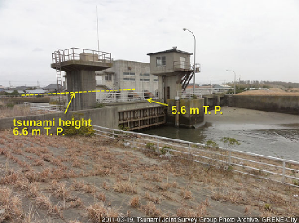
Fig. 13.6
Water gate at the Shimbori River mouth, Chiba Prefecture (March 19, 2011); measured
watermark height was 6.6 m T. P. and 1.0 m higher than the top of the gate (UTMS-0163 in the
TTSG database, location marked in Fig.
13.2
)
mouth, located 10 km north to the Kido River mouth (location marked in Fig.
13.2
).
In the residential area behind the water gate, only small fl ooding was observed by the
tsunami overfl owed the gate by 1 m. In contrasts to the large fl ooding damage in the
Kido River, the tsunami damage through the Shimbori River appeared to be reduced
by the water gate. The effectiveness of water gate is also observed in Ootsuchi, Iwate
Prefecture, where tsunami intrusion to the Koduchi River was minimized by the river
mouth water gate while tsunami fl ooding was signifi cant for the gate-less Ootsuchi
River. Tsunami intrusion into rivers and fl ooding via rivers are also observed in
many rivers such as the Samegawa River and the Kido River in Fukushima Prefecture,
the Kitakami River in Miyagi Prefecture and the Kesen River in Iwate Prefecture
(e.g
.
Tanaka and Nguyen
2012
; Sanuki et al.
2013
; Liu et al.
2013
).
13.2.2
Nakoso Coast
Nakoso Coast is a sandy pocket beach in Fukushima Prefecture facing to the Pacifi c
Ocean. Figure
13.7
presents the general layout of the area. It is an arc-shaped con-
cave beach with an approximate length 7 km and isolated by two headlands, Cape
Ryuugu on the north end and Cape Unoko on the south end. The Samegawa River, as
Search WWH ::

Custom Search