Environmental Engineering Reference
In-Depth Information
Group (hereafter referred to TTSG
2011
) (e.g., Mori et al.
2011
; Mori and Takahashi
2012
). Coastal damage was found to depend on various geophysical properties, such
as the incident tsunami height, marine bathymetry, nearshore and coastal topogra-
phy, and conditions of shore protection structures (e.g
.
, Shimozono et al.
2012
).
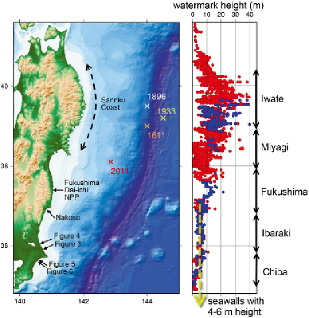
Many seawalls were collapsed especially on the Sanriku Coast which had expe-
rienced a series of historical Sanriku Tsunamis such as 1611 Keicho Tsunami, 1896
Meiji Tsunami and 1933 Showa Tsunami. Trans-Pacifi c 1960 Chilean Tsunami also
affected the district. The height of the 2011 Tohoku Tsunami was much larger than
the height of seawalls designed on the basis of these historical tsunamis, and
therefore destroyed seawalls resulting in catastrophic fl ooding in the coastal area.
Maximum tsunami runup reached 40 m above sea level in Iwate Prefecture. It was
sometimes diffi cult there to estimate the mechanism of seawall destruction since the
seawalls were completely broken by the tsunami much larger than the design level.
On the other hand, in the area south to the Fukushima Prefecture, the tsunami height
was of the same order with the height of seawalls. Figure
13.1
illustrates the tsunami
watermark heights in the TTSG database compared with the height of seawalls in
Fig. 13.1
Tsunami watermark heights along the east coast of the Honshu Island compiled in the
TTSG database
Search WWH ::

Custom Search