Environmental Engineering Reference
In-Depth Information
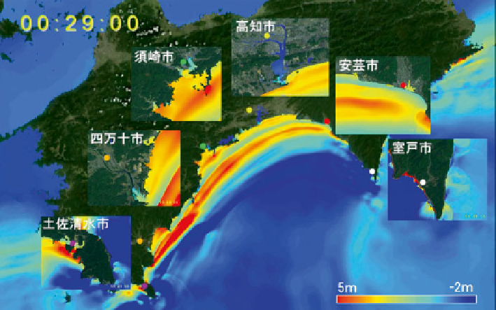
Fig. 12.9
Tsunami simulation focused on Kochi prefecture. Total grid numbers are 680 million
with about 5 m-grid-spacing for the coast along the whole Kochi prefecture. About 7 h took for the
5 h calculation using 5,184 nodes of K-computer, which is the fastest supercomputer in Japan
are indispensable for disaster reduction of earthquakes and tsunamis. And, if the
tsunami source is accurately acquired in real time from the offshore observation, we
can execute a high-speed tsunami simulation such as shown in Fig.
12.9
using high-
performance computers that provide us accurate prediction of tsunami (Baba et al.
2014
). Such information will contribute to the speedy preparations for rescues. In
Japan, not only DONET1, DONET2, but also, another cabled network project has
started to monitor the East Japan seismogenic zones.
12.4
Future
We deployed the advanced ocean fl oor network off Kii peninsula not only in the
Tonankai seismogenic zone, but also for the Nankai seismogenic zone. We have
started to apply the data from network for disaster mitigation and seismological
research with the advanced simulations. In the near future, the necessities for moni-
toring southwestern Japan seismogenic zone that includes Kyushu Island and
Okinawa Islands by the ocean fl oor networks will be increasing and indispensable.
We will continue to develop advanced ocean fl oor network cable technologies and
data analyses researches for realizations of the future ocean fl oor network plans.
It is also needed to integrate the ocean and land network data, and further to collabo-
rate with international network systems making a global network for progresses in
geosciences and mitigations of the earthquake and tsunami disasters.
Search WWH ::

Custom Search