Environmental Engineering Reference
In-Depth Information
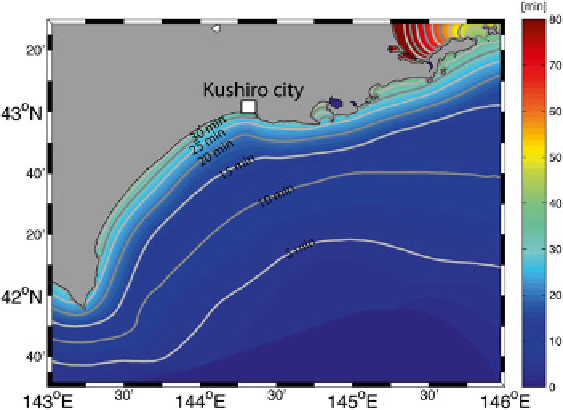
Fig. 11.9
Tsunami travel time map for the hypothetical earthquake simulated by the tsunami
numerical model
model are shown in Fig.
11.8
. From the tsunami simulation, the hypothetical tsu-
nami would hit the shore of Kushiro City approximately 35 min after the earthquake
was generated (Fig.
11.9
).
The tsunami inundation forecast for the hypothetical fault model that is produced
by the NearTIF algorithm is shown in Fig.
11.10
. The tsunami inundation that is
simulated by numerical forward modeling directly from the hypothetical fault
model is shown in Fig.
11.11
. These two tsunami inundation results are very similar.
The NearTIF algorithm can give tsunami inundation forecast within 2 min after the
earthquake source parameters are obtained, whereas the forward numerical model-
ing required approximately 70 min to obtain a result. This rapid result is the main
advantage of using the NearTIF algorithm rather than a forward numerical model to
produce tsunami inundation forecast maps. The use of the NearTIF algorithm can
signifi cantly reduce the time required to produce a tsunami inundation forecast map
without compromising the accuracy very much.
11.6
Tsunami Evacuation Drill in Kushiro City, Hokkaido
A tsunami evacuation drill in Kushiro City involving the city residents was set up
with the assistance of the NHK Television Network (
2013
) (Fig.
11.12
). One of the
purposes of this drill was to see how a tsunami inundation forecast infl uences the
decision making for evacuation by the participants.
Search WWH ::

Custom Search