Environmental Engineering Reference
In-Depth Information
1.1
Introduction
The East Japan Earthquake Disaster on March 11, 2011 (EJED) resulted in 18,916
dead or missing, 129,472 buildings with severe damage, and 255,977 with minor
damage. Most of the damage was due to the tsunami. The Iwate, Miyagi, and
Fukushima Prefectures were especially impacted (Level 1 Disaster Response
Headquarter
2012
).
After this catastrophe, the national government established two categories of
tsunami hazards: level 1 and level 2. A level 1 tsunami occurs once every 100 year
statistically. The strategy for a level 1 tsunami is to “prevent damage” through activ-
ities such as constructing sea walls at the height of a level 1 tsunami. In contrast, a
level 2 tsunami occurs once every 1,000 years statistically. The strategy for a level
2 is to “mitigate damage”. To save lives, the comprehensive disaster reduction plans
include land use regulations and tsunami warning systems.
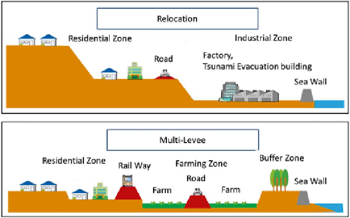
The recovery project from the EJED was undertaken considering these two levels
of tsunamis. Resettlement to higher ground or creating mounds on lower land is
now planned in the impacted areas. Figure
1.1
shows the concept of the land use
plan for recovery projects.
The area impacted by the EJED has been hit by a tsunami every 30-50 year,
including the 1896 Meiji Tsunami Disaster, the 1933 Showa Tsunami Disaster, and
the 1960 Chili Tsunami Disaster. After every disaster, residents in the impacted area
move to resettlement sites on higher ground. However, over time people return to
the low land near the sea due to variety of reasons, such as population growth or the
Fig. 1.1
Land use plan concept (Source: Miyagi Prefecture Recovery Plan)
Search WWH ::

Custom Search