Environmental Engineering Reference
In-Depth Information
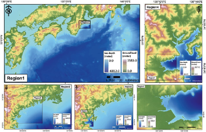
Fig. 10.2
The designed nested grid system as the input for tsunami modeling in Owase City
1979
). This assumption was based on the present condition of the Sendai plain,
where there are almost no houses or the other structures remaining after the 2011
tsunami. In Owase City, conversely, houses, buildings and the other man-made
structures are plentiful. Therefore, the effect of those structures should be taken
into account in the numerical model. We decided to integrate the macro-roughness
features, such as houses, sea wall and others, into the digital elevation model. This
is a practical way to represent the actual city condition in a pre-disaster situation
(Muhari et al.
2011
).
10.2.2
Tsunami Source Model
The tsunami source models in both locations were determined by using a determin-
istic method based on the available historical data in each area. For the Sendai plain,
tsunamis coming from the northern part of the Japan Trench (northeast region of
Honshu Island) have lower impacts compared those occurring in the central and
southern parts of the Japan Trench, as indicated by the tsunami run-up database
(Iwabuchi et al.
2008
). However, only limited historical data were available for
earthquakes in the central and southern parts of the Japan Trench. Recently, paleo-
tsunami research has shown evidence of past tsunami inundations of the Sendai
plain (e.g., Minoura et al.
2001
; Sugawara et al.
2013
), but the reliability of the
estimated magnitudes is still being discussed (e.g., Namegaya and Satake
2014
).
Search WWH ::

Custom Search