Geology Reference
In-Depth Information
4 THE GREATEST KARST AQUIFER IN FRANCE: THE
FONTAINE DE VAUCLUSE
4.1 General description
4.1.1 Location
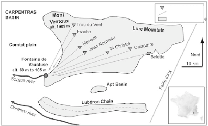
The Fontaine de Vaucluse is the largest spring in France (23 m
3
·s
-1
), located
at the southwestern end of the North-Provence block, a triangular limestone
unit including the Mont Ventoux and the Montagne de Lure (alt. 1909 m) to
the north, the St. Christol plateau in the center (alt. 1256 m) and the Monts de
Vaucluse (1000 m) to the south (Figure 30). It includes a deep basin located at
the base of a steep scarp, above a dead-end karst valley, and an assemblage
of perennial exsurgences located between 60 and 83 m of elevation.
shaft or sinkhole
proven connexion
Cretaceous limestone
North
Lubé
ron ra
nge
Figure
30
Location of the Fontaine de Vaucluse and position of tracer tests.
The basin is an equilibrating chimney for the system, its level varing
with the discharge (Figure 31). In high water periods, it overfl ows at the
elevation of 105 m a.s.l. In low water periods, its level drops 20 m. Numerous
diving attempts with an aqualung fi nally succeeded in reaching a depth of
205 m (Hasenmayer in 1984), the limit of human exploration, and the rest
of the submerged chasm was explored with remote controlled robots. The
bottom of the chasm, 308 m deep, was reach by the Modexa ROV in 1985
(328 m below the level of the spillway, so 224 m below sea level).


Search WWH ::

Custom Search