Geology Reference
In-Depth Information
Question 1:
Draw a piezometric map for the superfi cial and deep aquifers.
Specify the drainage conditions of each aquifer.
Question 2:
Does the piezometric data enable the identification of
exchanges between the two aquifers? If yes, to what could such exchanges
be attributed?
Answer 1 (Figure 21)
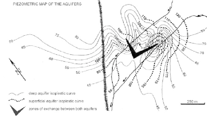
Figure 21
Piezometric map of the aquifers.
The superfi cial aquifer has a general east to west drainage, following
the local drainage direction of the stream network. Its roof is located only
a few meters below the natural ground surface.
The deep aquifer shows drainage toward the south, organized along
several axes converging towards a single collector toward the southern
spring (confi rmed by tracer tests). The depth of its surface varies from 15
to 70 m.
Answer 2:
Two inter-aquifer exchange areas are revealed by the cartographic synthesis,
and indicate local recharges of the deep aquifer by the shallow aquifer. These
mixing zones are revealed by marked depressions in the shallow aquifer in
the same location as piezometric domes in the deep aquifer.
These exchanges are locally caused by two complementary factors:
• on the one hand, deep wells that did not isolate the superfi cial aquifer
put the two aquifers into contact;
Search WWH ::

Custom Search