Geology Reference
In-Depth Information
PROBLEMS
Problem #1—Recharge elevation for water circulating in a
landslide
The La Clapière landslide, in the Mercantour range, has springs at its base.
The main problem concerning the hillside aquifer feeding these springs is
the determination of its recharge area. With this goal in mind, two water
sampling efforts enabled the sampling of springs with an easily identifi able
catchment area (Table 1 and Figure 1), in order to draw an oxygen-18/
altitude nomogram, and then determine the average recharge elevation
of the springs at the base of the landslide, for which the catchment area is
unknown.
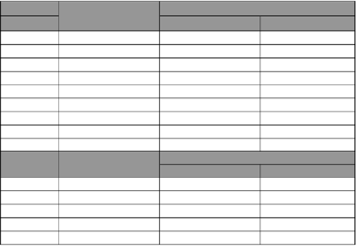
Table 1
delta
18
0 for different springs.
Reference
Recharge elevation (m)
δ
18
O
Point
1
st
sampling
2nd sampling
1
2,718
-12.16
-
2
2,371
-11.80
-
3
2,024
-11.83
-11.73
5
1,735
-11.53
-11.59
6
1,707
-11.55
-11.40
17°
1,089
-9.82
-
18°
1,355
-
-10.92
19°
1,307
-
-10.76
°off the map
Point
Elevation of the point
(m)
δ
18
O
1
st
sampling
2
nd
sampling
11
1,212
-11.02
-11.35
12
1,249
-11.37
-
14
1,105
-10.98
-10.86
15
1,110
-10.75
-10.84
16
1,128
-
-10.75
Search WWH ::

Custom Search