Geology Reference
In-Depth Information
The part of the dam that was destroyed was rebuilt immediately
upstream and anchored in Tortonian limestone, which explains the unusual
V shape of the new dam (Figure 133).
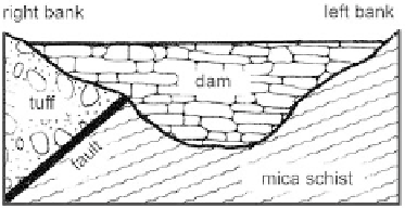
The Saint-Francis gravity dam in California (USA), 82 m high and
set, for the most part, on foliated mica schist, put into contact with
volcanic tuff (conglomerate cemented by clay) by a fault on the right bank
(Figure 134).
Figure 134
Saint-Francis dam (USA). Relationship between the dam and the geologic structure
(from Letourneur & Michel, 1971).
The vulnerability to weathering of the tuff and the permeability
contrast between the two formations allowed water to pass through
the disaggregated tuff near the fault and is likely to have generated an
accumulation of water pressure, leading to the sudden failure of the dam
on March 13th, 1928 (Lugeon, 1933; Gignoux & Barbier, 1955; Letourneur
& Michel, 1971).
2.2 Effects of water pressure
The most striking example is provided by the Malpasset arch dam in the
Var (France), the construction of which fi nished in 1954, and the left bank
support of which failed suddenly on December 2nd, 1959, leading to a
catastrophic outpouring from the reservoir.
With a height of 66.5 m over a length, across the top, of 222 m, the
dam was founded entirely on the foliated two-mica gneiss of the Tanneron
mass, containing pegmatite veins (alternating dark micaceous beds and
light-colored quartzo-feldspathic beds). In addition, the site is cut up by a
network of faults along two principal directions, N 80 dipping north, and
N 150 dipping southwest. This last group can even be confused with the
direction and dip of the foliation (Figure 135).
The studies performed after the accident revealed the existence of a N 80
fault, limiting the downstream lip of the left bank failure, and also visible on
the right bank. The fault, covered with clayey breccia of variable thickness,
Search WWH ::

Custom Search