Geology Reference
In-Depth Information
it can be helpful to look for it around the borders of the study area, using
calibration sections in simpler areas, and then to integrate them into the
relevant cross-sections.
Sometimes, the deep structure of an aquifer can be subject to multiple
interpretations, which must then be described and illustrated, along with
their limits and imprecisions.
When the network of available information allows it, it can be interesting
to represent the subterranean structure of an aquifer with the help of an
isohypsal map (curves of equal elevation) of its fl oor (for unconfi ned
aquifers) or its roof (for confi ned aquifers). The characterization of the
roof of the substratum is often of the fi rst importance in understanding
and studying the storage and circulation conditions of superfi cial aquifers,
particularly in the case of hillside aquifers, which can exist in scree slopes
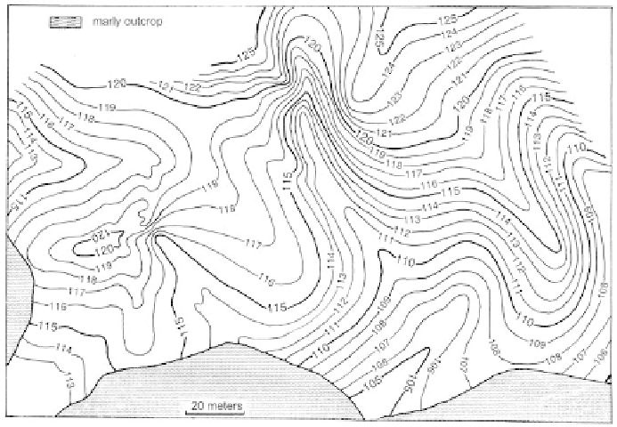
covering a wide extent. Figure 60 is an example illustrating the roof of a
marly bedrock unit outcropping at the foot of a slope between 105 and 110
m of elevation. The map shows the bedrock unit continuing up to elevations
of 120 to 125 m, and shows the deep incuts affecting the bedrock, probably
fi lled-in fossilized paleothalwegs.
Figure
60
Scree cover on Cenomanian marl on the right bank of the Paillon in Cantaron
(Alpes-Maritimes). Isohypsal map of the roof of the marly bedrock.
The same type of representation can be used for the bedrock of alluvial
aquifers which outcrops laterally on hillsides. It can also be combined with
transversal cross-sections following the variations in facies within alluvial
Search WWH ::

Custom Search