Geography Reference
In-Depth Information
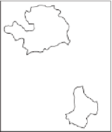
Input layer
Erase layer
Output layer
Figure 5.6
Polygon erase.
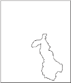
Clip layer
Output layer
Input layer
Figure 5.7
Polygon clip.
Erase creates a new layer by overlaying two sets of features. h e polygons of the
erase layer dei ne the erasing region. Input layer features that are within the erasing
region are removed—this is illustrated in Figure 5.6. h e erase operator can be used
with polygons, lines, or points as inputs.
h e clip operator is similar to erase except that the features that are within the
clip region are preserved. Like the erase operator, the clip operator can be used with
polygons, lines, or points as inputs. h e clip operator is illustrated in Figure 5.7.
5.2.4
Applications and problems
Overlays of various kinds are central to many GIS-based projects. A large proportion
of applications that utilize multiple spatial attributes make use of overlay procedures.
As an example, Sprague
et al.
(2007) are concerned with assessment of the persistence
of rice paddies within the Kanto Plain of Japan. In that study, historic (i.e. late nine-
teenth century) maps were georeferenced to a modern map using features that appear
on both the historic maps and modern maps. Overlay procedures were then used to


Search WWH ::

Custom Search