Geography Reference
In-Depth Information
2
1
2
2
1
2
1
1
3
1
3
3
1
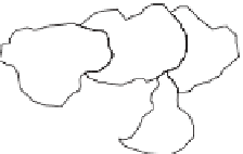
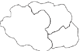
A
B
Figure 4.13
(A) Original polygons and (B) polygons with internal boundaries dissolved.
of the variable (Martin, 1996). Raster cells can also be conceptualized as zones and the
spatial resolution of a raster will similarly determine results.
Merging polygons
4.10
Related to the previous theme, a common operation in GIS contexts is the merging of
polygons with common attributes (this is sometimes termed the 'dissolve operator').
For example, if we have sets of areas all of which have the same area code then we may
wish to merge those areas where their boundaries are adjacent. If there are several
zones within one larger administrative area, all of which have the same zone identity,
then if we dissolve the internal boundaries (i.e. the boundaries of the small zones) we
are let with the boundaries of the larger administrative areas. Figure 4.13 gives an
example.
Summary
This chapter was concerned with some very basic operations, but such methods form
the core of many GIS-based analyses. Measurement of straight line (Euclidean) dis-
tances, an initial focus of this chapter, is sensible in many contexts; in others they may
not be meaningful. For example, the movement of airborne pollutants is a function of vari-
ous factors, such as wind direction, and simple distance may explain such a process
only to a very limited degree. Also, buffers may only be useful in particular contexts. If we
are concerned with accessibility of a particular location in a populated area then mea-
suring the straight line distance of places to that location may not be very helpful. Instead,
we may wish to measure distances (and perhaps calculate travel times) along a road
network (perhaps using the approach detailed in Section 6.5). Other ways of accounting
for the 'cost' of moving from one place to another include cost (or friction) surfaces and
this idea is discussed in Section 10.6. Following the discussion about distances, areas,
and buffers, some particular concepts in spatial analysis were introduced. These
included moving windows, geographical weights, spatial dependence and spatial


Search WWH ::

Custom Search