Geography Reference
In-Depth Information
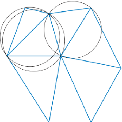
Figure 9.2
TIN subset with circumcircles superimposed.
raster-based digital elevation models (DEMs) as, in the latter case, elevations are stored
at all locations on a regular grid while with TINs the sampling density can be varied as
a function of the nature of the topography. Generally, marked breaks of slope are repre-
sented and there are usually more samples in areas with more variable elevations and
fewer samples in relatively l at areas. Various approaches exist for the selection of obser-
vations with the objective of representing the surface as precisely as possible with the
minimum of redundancy. One widely used approach to select points from a regular grid
is the very important points (VIP) algorithm. With this approach, points are assigned
a signii cance that is a function of the dif erence between each point and its neighbours.
Following this procedure a specii c number of the most signii cant points can be retained
or points could be retained such that the loss of accuracy is minimized (Li
et al.
, 2004).
A TIN can be constructed from known point values using a process called Delaunay
triangulation. Peuker
et al
. (1978) provide a detailed account of TINs. With Delaunay
triangulation, the triangles are formed such that the circumcircle of each triangle con-
tains no vertices other than those that make up the triangle. h e circumcircles for a set
of triangles are shown in Figure 9.2. As can be seen in the i gure, the circumcircle runs
through the three vertices that belong to a given triangle and in no case does a circum-
circle for a given triangle contain any vertices other than those that belong to that tri-
angle. With Delaunay triangulation, two vertices are connected if their h iessen
polygons share an edge, and this is illustrated in Figure 9.3. Delaunay triangulations
can be derived from h iessen polygons. Li
et al.
(2004) outline a variety of alternative
approaches to selecting the starting point for, and conducting, Delaunay triangulation.
A TIN is illustrated using the Walker Lake sample of 470 point observations.
h ese data come from the topic by Isaaks and Srivastava (1989), and are provided
through the AI-Geostats website (see http://www.ai-geostats.org/index.php?id=data).


Search WWH ::

Custom Search