Database Reference
In-Depth Information
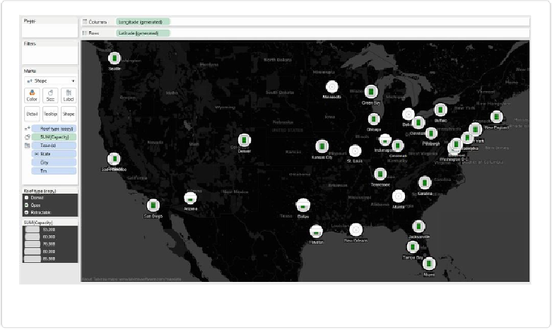
Figure 11-8. Mapping football team stadium types using custom shapes
If you were asked to quickly tell the locations of the domed roof stadiums (indicated by the
white round shape a circle in the center), you could spot them rather quickly — all are loc-
ated in the central section of the country. You could also quickly see that all but one of the re-
tractable roofs are in the southern states. These patterns are very difficult to spot when the in-
formation is given in a table, but they reveal themselves with a minimum amount of interrog-
ation when shown on a map: the audience gets an immediate return on very little effort.
But there are some issues with this map. Some shapes are hidden or partially covered, such
as the stadium shape for San Francisco, which is almost entirely underneath the stadium
shape for Oakland. I can't imagine fans of either team approving of this configuration. Simil-
ar occlusion of logos is happening in the Northeast, where the stadium shapes for the two
New York teams overlap heavily.
This can be partially remedied by adding Annotations to the shapes that are clustered. If we
right-click on each shape, select
Annotate
and then
Mark
, we can edit the resulting dialog
box to make sure the data field
<Tm>
is displayed. The team acronym appears on the map
with an arrow pointing to the shape.
We can move the resulting annotations to the desired locations on the map and then right-
click each one and change its format. I prefer to remove the arrows from the line ends and