Graphics Programs Reference
In-Depth Information
enter coordinates in the format
@distance<angle
, in which the distance is in feet
and hundredths of a foot and the angle is in surveyor's units to the nearest minute.
introducing Surveyor's units
Surveyor's units, called
bearings
in civil engineering, describe the direction of a
line from its beginning point. The direction (bearing), described as a deviation
from the north or south (up and down along the y-axis) toward the east or west
(right and left along the x-axis), is given as an angular measurement in degrees,
minutes, and seconds. The angles used in a bearing can never be greater than 90º,
so bearing lines must be headed in one of the four directional quadrants: north-
easterly, northwesterly, southeasterly, or southwesterly. If north is set to be at the
top of a plot plan, then south is down, east is to the right, and west is to the left.
Therefore, when a line from its beginning goes up and to the right, it's headed in a
northeasterly direction; when a line from its beginning goes down and to the left,
it's headed in a southwesterly direction; and so on. A line that is headed in a north-
easterly direction with a deviation from true north of 30º and 30 minutes is shown
as N30d30
′
E in AutoCAD notation. Figure 13.2 shows examples of a line drawn
using surveyor's units.
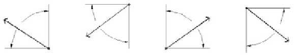
FiGuRE 13.2
Drawing a line using surveyor's units
With the surveyor's unit system, a sloping line that has an up-and-to-the-left
direction has a down-and-to-the-right direction if you start from the opposite
end. So, in laying out property lines, it's important to move in the same direction
(clockwise or counterclockwise) as you progress from one segment to the next.
The bigger reason to ensure that lines move in the same direction relates to
the way property is recorded. In addition to a drawing, or
plat
as surveyors call
it, each piece of property also has what is known as a legal description. This legal
description defines one corner as the starting or control point, and then proceeds
to textually describe a piece of property using bearings and distances. Each bear-
ing and distance builds upon the previous and constructs what surveyors call a
traverse.
Constructing, balancing, and closing traverses is a topic unto itself. The point
in introducing you to this concept is to help you understand how the geometry


Search WWH ::

Custom Search