Geoscience Reference
In-Depth Information
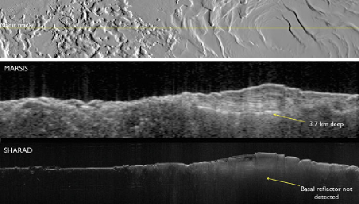
Fig. 5.3
Comparison of MARSIS and SHARAD radargrams on Mars south pole (Image credit:
NASA/ESA/JPL-Caltech/University of Rome/Washington University in St. Louis)
5.5
MARSIS and SHARAD Scientific Accomplishments
MARSIS and SHARAD were originally designed with the primary scientific task
of investigating the presence of water, both solid and liquid, on the Martian surface
and subsurface. But the information on Mars achieved using their data exceeded by
far the initial expectations.
MARSIS was the first instrument to show the cross section of Mars craters,
highly contributing to their structure analysis. It was also capable to identify buried
craters not detectable with other instruments. Data from Chryse Planitia, a mid-
latitude northern lowland region covered by sediments delivered from the highlands,
revealed the presence of a buried quasi-circular structure with a diameter of 250 km
which is probably an impact basin. MARSIS data also show a planar structure which
suggests the presence of a deposit more than 1 km thick (Picardi et al.
2005
). On the
basis of the analysis of comparable exposed basins on Mars, the data leads to the
conclusion that the feature could be the basin floor or a boundary between layers of
basin fill. Figure
5.4
shows Martian craters both exposed and buried.
MARSIS data gave evidence of other buried impact basins in the northern
lowlands of Mars. Before Mars Express mission, the Mars Orbiter Laser Altimeter
(MOLA) on Mars Global Surveyor revealed quasi-circular depressions interpreted
as ancient impact craters filled by materials in later eras. Analyzing MARSIS data,
Watters et al. (
2006
) identified 11 buried basins, many of which have not been
detected by imaging instruments. Though, on the basis of MARSIS data, it will
not be possible to discover all the buried basins. In fact, in order to be detected, a
buried crater must be filled with materials having a dielectric constant sufficiently
Search WWH ::

Custom Search