Geoscience Reference
In-Depth Information
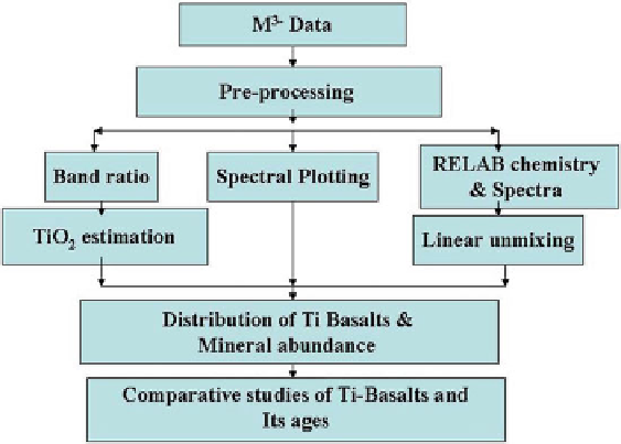
Fig. 2.2
The flow chart showing methodology adopted in the study
2.3.1.1
Data Acquisition and Preprocessing
The Orientale basin data has been downloaded from the orbital data explorer with
reference to latitude and longitude information. The Chandrayaan-1 M
3
operates in
two modes, including global mode and target mode. The data used here is acquired
from global mode, which provides 85 bands in the spectral interval of 20-40 nm
covering spectral range between 400 and 3,000 nm. The spatial resolution of global
mode M
3
data is 140 m/pixel (Green et al.
2007
; Pieters et al.
2009
).
The preprocessing involves geo-referencing and apparent reflectance conversion
from the given radiance. Using the glt file which carries information about latitude
and longitude, the radiance data have been geo-referenced with ENVI software.
Based on the method described by Staid et al. (
2011
), apparent reflectance was
converted and bands were truncated at 2,500 nm, which also reduced additive
contributions due to emissivity.
2.3.1.2
Spectral Profile
The mineralogy composition of the planetary surfaces has been investigated for
decades using the visible and near-infrared (VISNIR) spectroscopy, owing to
the abundance of diagnostic mineral absorptions in the electromagnetic spectrum
(McCord et al.
1981
; Pieters et al.
1996
; Isaacson et al.
2011
).Spectral reflectance
Search WWH ::

Custom Search