Geoscience Reference
In-Depth Information
basin structure to view. The Orientale basin is important to our overall understanding
of the geology of large-impact basins on the lunar surface.
The Orientale basin has
930 km in diameter and covers an area of
700,0000 km
2
(Head
1974
); within the basin, the largest Mare Orientale covers
an area of
52,700 km
2
, and its volume is
46,000 km
3
(Whitten et al.
2011
).
Previous studies estimated that the thickness of the Mare Orientale was less than
1-2 km (Head
1974
; Solomon and Head
1980
) and possibly up to
1 km (Greeley
1976
; Scott et al.
1977
). With the advent of recent LRO wide-angle Camera (LROC)
image, the Digital Terrain Model of the Orientale basin and its spatial profiles have
been established; the depth of the Maunder crater situated in the Mare Orientale is
estimated as 6.04 km. Medium-Ti basalt flood eruptions fill much of the center of
the Orientale basin (3.70 Ga) (Kadel et al.
1993
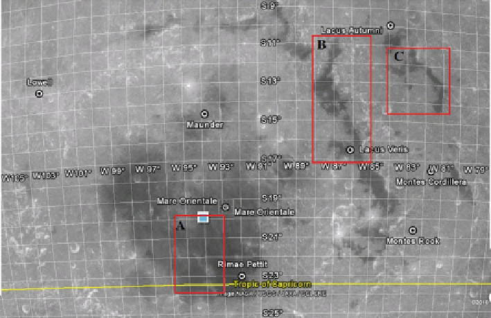
). The location of the Mare Orientale
(A), Lacus Veris (B), and Lacus Autumni (C) are shown in Fig.
2.1
, and the sites
selected for the analysis are marked in the square line.
The Lacus Veris has 396 km diameter and consists of five mare ponds, the largest
of which covers an area of
8,890 km
2
and the smallest of which is
145 km.
Lacus Veris (also called as Spring Lake) flat extent of North South lengthened
shape. The crescent-shaped Lacus Veris is situated between the two mountainous
rings constituting Montes Rook to the North and the floor filled with very dark
material. Medium-Ti (<4wt%TiO
2
) basalt signatures are present in the northern
Fig. 2.1
Mare Orientale basin and test sites selected for the present study. The test sites are marked
as (
A
) Mare Orientale South Central par, (
B
) Lacus Veris and (
C
) Lacus Autumni
Search WWH ::

Custom Search