Geography Reference
In-Depth Information
earthquakes have been concerned with the spatial
patterns created by seismicity. At the turn of the
millennium, efforts are under way to refine the
scales used to depict earthquake damage and other
effects (MM, MCS, MSK, JMA and GOST
scales—see Alexander 1993: pp. 28-31). This will
lead to improvements in the depiction of the
pattern and extent of earthquake damage and to
an enhanced ability to predict the medium- to
long-term seismicity of affected regions. A brief
exposition of the field methods involved in post-
earthquake intensity survey was given by
Choudhury and Jones (1996), while Gasparini
et
al
. (1992) discussed the statistical methods used to
compile isoseismal maps from questionnaire data.
Parametric models of the decline in intensity (and
therefore damage) from the epicentre of an
earthquake have been given in papers by
seismologists (e.g. Brazee 1979) and geotechnical
engineers (e.g. Seed
et al
. 1976).They tend to show
that the attenuation of strong motion with
distance from the fault is a function of source
characteristics (the most critical factor),
transmission path, geometric spreading, energy
absorption and local site conditions. However, no
geographer has yet risen to the challenge of
producing a distributed spatial model of
earthquake effects, although some moves in this
direction were made by Slosek (1986), who found
that deaths and injuries tended to decline
remarkably uniformly with distance from
epicentre regardless of the shape of the
macroseismic field, providing the pattern of
building collapse was taken into account.
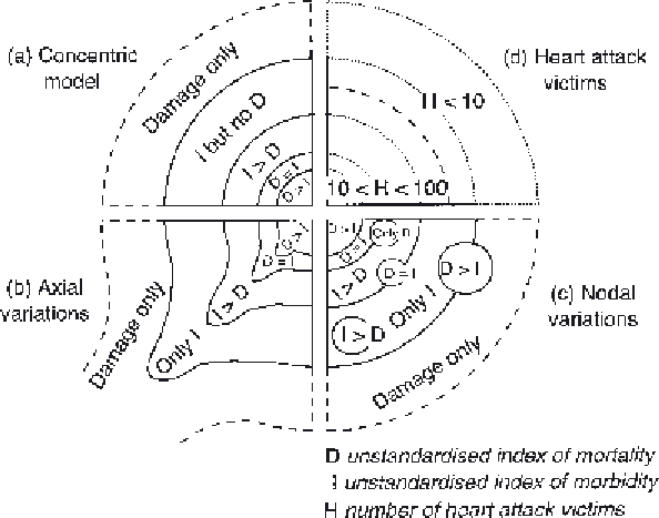
Moreover, using data from several earthquake
disasters, I generalised the spatial pattern of
earthquake casualties in a series of simple models
based on concentric variations, axes and nodes
(Figure 5.2; Alexander 1989—see also Alexander
1993: p. 466). However, more testing and further
refinements of such models are needed in order to
increase their explanatory power.
In this context, Degg (1989) found that damage
in the 1985 Mexico City earthquake varied
widely according to type of construction, height
of building and type of subsoil. Taller buildings
were damaged at greater distances from the
epicentre than were lower ones. Yet, Choudhury
Figure 5.2
Hypotheses of
the theoretical spatial
distribution of casualties
in earthquake disasters.
Source:
After Alexander 1989.