Geography Reference
In-Depth Information
during the life-cycle of a single cyclone. The
second concerns the varying spatial scales (in terms
of size of areal unit) at which cyclone frequency
or impacts can be studied and their
appropriateness for different purposes. The third
problem is that of the increasingly incomplete,
imprecise and unreliable data on cyclone
occurrences, tracks and characteristics as one goes
back into the past; coverage over ocean areas has
only become more or less complete during the
last three decades with the advent of satellite
imagery, thus raising problems about the
meaningfulness of many earlier maps of cyclone
frequency and assessments of changes in regional
cyclone frequency. Geographers have made some
significant contributions in designing analytical
strategies to accommodate or overcome these
problems.
Several geographers have mapped aspects of the
spatial distribution of cyclone frequency within
macro-regions by adopting a grid-square
approach. For example, McGregor (1995) assessed
spatial aspects of the cyclone hazard and
interannual variations in cyclone activity in the
China Sea by constructing and analysing a 2°×2°
grid-square database of six-hourly tropical cyclone
position data over the period 1970-89 for the area
105-125° E, 5-27° N. The approach led to maps
CASE EXAMPLES OF GEOGRAPHICAL
RESEARCH ON TROPICAL CYCLONES
AND THEIR IMPACT
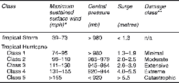
Tropical cyclones, which can be defined as closed-
circulation, warm-cored, low-pressure systems
with maximum sustained surface wind speeds (1-
minute mean) of at least 39 mph, are
conventionally divided into two intensity classes:
tropical storms (with maximum winds of 39-73
mph) and hurricanes (with maximum winds of at
least 74 mph). Hurricanes have been subdivided
into five potential damage classes depending on
their maximum wind speed, minimum central
pressure and storm surge magnitude in what is
termed the Saffir-Simpson damage potential scale
(Table 4.1) (Simpson and Riehl 1981). Although
most work on cyclones has been accomplished by
meteorologists, particularly in the United States,
geographers have contributed to cyclone research
in four principal ways.
The assessment of spatial distribution of
the cyclone hazard
Three data problems bedevil objective assessments
of the cyclone hazard. First, cyclones vary in
intensity and size both between cyclones and
Table 4.1
Classification of tropical cyclones with hurricane classes
based on the Saffir-Simpson damage potential scale.
Source:
After Simpson and Riehl 1981.
Notes:
*100 mph=160.9 kph=86.88 knots.
** For details of damage associated with each class, see Simpson and Riehl
1981: pp. 366-8.