Geography Reference
In-Depth Information
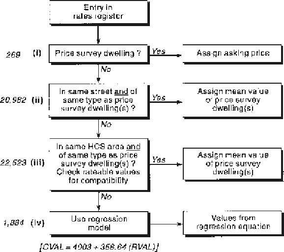
Figure 44.3
The sequence
of GIS-based operations in
the modelling of house
prices.
is different for the simple reason that it is located
on a unique part of the Earth's surface—and even
at fine scales of resolution this can lead to dramatic
differences between the values of two properties if
one happens to be located 'on the wrong side of
the tracks'. There is not space here to discuss the
findings in any great detail, although the reader is
referred to Longley
et al.
(1994) in the Guide to
Further Reading. Briefly, the modelled results
were compared with the official council tax
valuation list (used to determine how much
council tax every household should pay) and
found to be similar, both in absolute values and
distribution of values. There were, however, streets
in which either positive or negative differences
were observed, and the geographical distribution
of such streets is shown in Figure 44.4. Such
patterns beg interesting questions in both
methodological and substantive terms. Was the
model too simple to replicate 'official' values in
these areas, and might it have been improved by
adding in other factors—for example, the localised
effects of gentrification upon house prices in
specific neighbourhoods? Or might the official
valuations themselves have been systematically
wrong? —property valuation is at best an inexact
science, and there is no real way of ascertaining
the 'true' value of housing in a city, except perhaps
if every house were put up for sale in order to let
the market decide! And, third, if house prices have
indeed been modelled successfully in one time
period, could the model be updated with new
house price data in order to reflect the
geographical dynamics of house price change? At
some point, government will have to produce
comprehensive revaluations of all properties in
order to retain fairness in the sharing of the local
tax burden, and this kind of GIS-based model
would seem to offer a way forward that is
transparent, cost-effective and fair. These issues are
summarised in Box 44.1. The results of this simple
geographical model suggest that GIS provide an
ideal medium for assessing the relative importance
of structural and locational attributes in creating
value. Generalising from this, Orford (1997) has
also described how a wide range of
neighbourhood and structural attributes may be
incorporated into sophisticated GIS-based