Geography Reference
In-Depth Information
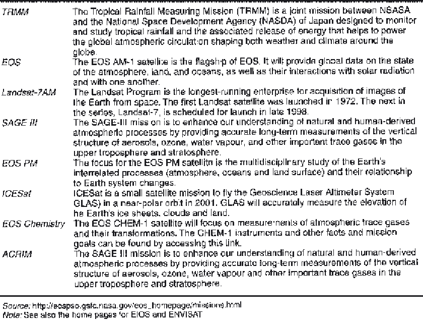
Table 40.1
A summary of some of the types of data that will be available as part of NASA's Earth Observing
System (EOS).
Most modern mapping agencies now produce
maps in digital format. One can see the kinds of
product that are available by visiting, for example,
the web site of the Ordnance Survey of Great
Britain (see section on additional sources, below).
In the past, such maps have been produced by
converting paper maps into machine-readable
formats. Today, however, modern survey
techniques are such that information can be
collected directly in digital format and used to
create a computer database from which various
map products are derived.
In addition to the digital mapping produced
by national mapping agencies, a range of more
specialist products is also available. In Britain, for
example, we can obtain information on soils from
the Soil Survey and Land Research Centre,
geological information from the British
Geological Survey, and species records data from
the Biological Records Centre. A review of UK
rural data resources is given by Haines-Young and
Watkins (1996). At the international level, spatially
referenced environmental data can be obtained
under the aegis of the United Nations
Environment Programme (UNEP-GRID). The
web addresses of these organisations are also given
at the end of this chapter.
Automating data capture in the field
Automated techniques for data capture in the
field are now being widely used. Thus, for
example, hydrological or climatological
measurements can be made on a continuous basis
and the data transmitted back to the laboratory
or base station. Such data can be input directly