Geography Reference
In-Depth Information
notion of journey-to-crime, showing the strong
distance decay effects linking offender residence
and the place of the crime, but a more fruitful
framework has been developed by Paul and
Patricia Brantingham in their work on the
geometry of crime (Brantingham and
Brantingham 1981). This suggested that crime
would be concentrated where the offender's
perception of opportunity (awareness space)
overlapped with actual opportunities in the
environment. Offenders' perceptions are skewed
towards areas in which most of their normal
legitimate activity takes place—home, school,
work and leisure.
In the last decade, the dualism of offence and
offender has been reaffirmed, although the slant
has been less towards theoretical understanding of
offender behaviour and more towards its
pragmatic utility for crime prevention and
policing. Developments in offender profiling
explicitly aimed at managing risk, rather than pure
rehabilitation, are beginning to show their
potential. This is not just about psychology but
about all aspects of the predictability of serial
offending. Geographical profiling is one element
in the crime analyst's toolkit, aided by mapping
technologies provided by geographical
information systems (GIS) to display patterns of
offending, known associates and
modus operandi
against demographic, land-use or other
information relevant to the distribution of
potential targets. Equally, these techniques are used
to identify hot spots of crime —clusters of
offences in particular locations (Hirschfield
et al.
1996; Sherman 1995) —using the power of
modern computers to provide regular updates that
highlight patterns as they happen rather than after
the event.
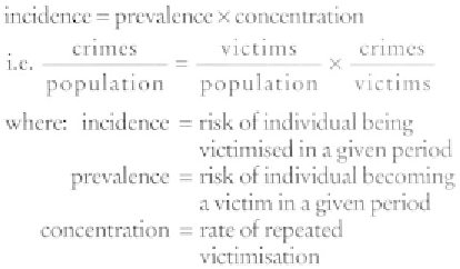
victims, who previously had been the forgotten
item. Much of this knowledge relates to the risk
of victimisation, where it is important to recognise
the distinctions summed up by the simple
equation:
So a high rate of victimisation can mean a few
people repeatedly victimised (for example,
domestic violence) or many people rarely
victimised more than once (e.g. pickpocketing).
The role of repeat victimisation has only recently
been fully recognised. It applies to all the high-
volume categories of crime—in 1995, 19 per cent
of burglary victims suffered two or more
victimisations, 28 per cent of car crime victims,
and 37 per cent of contact crime victims
(wounding, assault, mugging, snatch theft). We
know that there is diffusion of repeat victimisation
across crime types (being a victim of violence
increases your risk of burglary, and
vice versa
), but
as yet little is known about the geography of
repeats.
The various sweeps of the British Crime
Survey show a persistent association of the
incidence of victimisation with certain types of
neighbourhood. High risks tend to be associated
with the poorest council estates, mixed inner
metropolitan areas and high status non-family
areas. Conversely, the lowest risks are associated
with agricultural and retirement areas, modern
high-income family housing, and affluent
suburban areas. However, these are very much
generalisations subject to considerable variation
between types of victimisation. Area risks interact
with other risks (demography, lifestyle and status)
to produce complex patterns, for example the
Victims
Victims are the crucial element in the criminal
process. Numerically, they make the bulk of
decisions about crime, without which no incident
would enter the criminal justice system. The
introduction of victim surveys over the last twenty
years means that we now know more about