Geography Reference
In-Depth Information
Box 31.2
Social disintegration and the geography of AIDS in the Bronx, New York
The Bronx, with a land area of 109 km
2
and a population
of about 1.2 million, is a borough of economic extremes.
Some of the most affluent districts of New York City are
located in the northwest of the borough. By contrast, the
districts in the west and southwest ('South Bronx') are
populated largely by ethnic minorities and rank among the
most impoverished ghetto areas of the United States. That
same area is also the focus of a major epidemic of
intravenous (IV) drug use and, with it, an intense epidemic
of HIV/AIDS. Thus, as early as the mid-1980s, the sharing
of injecting equipment had resulted in the dissemination
of HIV to 10-20 per cent of all young adult males in the
South Bronx (Drucker and Vermund 1989). To give an
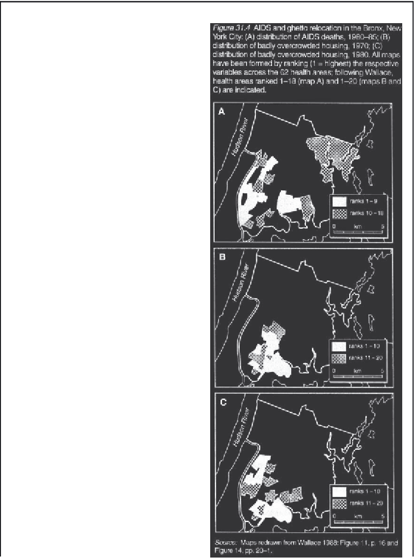
impression of the geography of this early spread process,
Figure 31.4A plots those Bronx Health Areas ranked 1-9
(solid shading) and 10-18 (cross-hatched shading) in
terms of AIDS deaths during the period 1980-85. The
overall pattern is dominated by the southern and western
health areas, which constitute the South Bronx, with
secondary foci in the central and northern Health Areas.
Socio-spatial variations in health can be directly
influenced by public policies, inadvertently or deliberately.
In the instance of the Bronx, Wallace (1988; 1990) argues
that the spatial patterns of IV drug use during the early
1980s, and the resulting spread of AIDS to its 1985 pattern
(Figure 31.4A), were inextricably linked to a covert policy of
so-called 'planned shrinkage'. In order to clear impoverished
areas of New York City, essential municipal services were
withdrawn or dramatically reduced in parts of the South
Bronx during the 1970s. This resulted in a mass relocation
of the South Bronx population as the housing infrastructure
began to deteriorate. To give an impression of this
relocation, Figure 31.4B maps those Health Areas ranked
1-20 in terms of badly overcrowded housing in 1970.
Similarly, map C shows the equivalent pattern for 1980.
Together, the maps indicate a 'contagious-like' relocation of
ghetto areas from the central area of the South Bronx to
neighbouring areas in the west and east.
A large body of evidence in sociology, criminology,
psychology and the health sciences (see, for example,
Wallace 1988; 1990) relates the dislocation of social
networks to a nexus of public disorder, violence, drug
use, prostitution and disease. Given that some of these
behaviours are associated with HIV transmission, the
forced displacement and community dislocation of
populations to the west and east of the South Bronx may
have actively fuelled the spread of HIV in these areas. To
assess this hypothesis, Wallace (1990) has examined the
manner in which two measures of HIV-related behaviour
altered during the course of planned shrinkage. The two
measures, which have been assessed for each of the
Health Areas of the Bronx, are (1) the average number
of liver cirrhosis deaths (denoted y
1
); and (2) the average
number of intentional violent deaths (y
2
). Both variables
serve as markers of the geographical distribution of drug
use in the Bronx; liver cirrhosis can be a direct health
outcome of drug use, while the association between
violent crime and drug use is well established.
To determine whether the geographies of these HIV-
related behaviours were driven by social dislocation,