Geography Reference
In-Depth Information
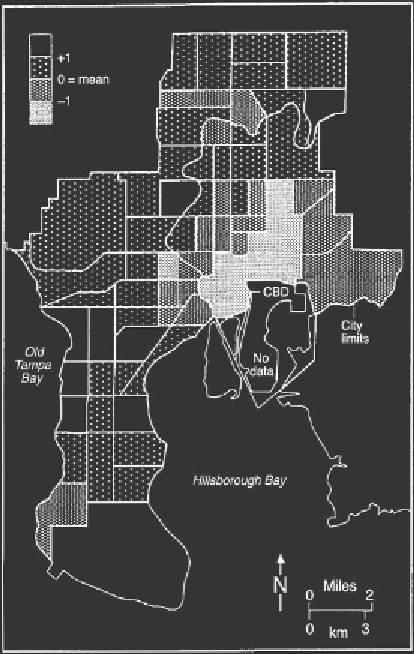
Figure 29.5
Variations in social well-being in Tampa.
distribution of the problem in Glasgow over
recent decades. In 1971, a higher proportion of
deprived areas were located in the inner city,
particularly in the East End and the Maryhill
Corridor (Pacione 1989). Over the intervening
period, the traditional inner tenement housing,
which previously exhibited severe deprivation,
recorded a relative improvement in status largely
as a result of massive clearance and redevelopment
by the local authority, combined in some areas,
like GEAR, with modernisation and new building
aided by housing associations and private
developers. This process involved the large-scale
relocation of residents in a general process of
decentralisation. The inner areas now contain a
much reduced and ageing population living in
improved accommodation. Conversely, the outer
estates exhibit a younger demographic structure
and, while the housing is generally well provided
with basic amenities, overcrowding is widespread.
Serious social problems such as unemployment
and a high proportion of single-parent families are
also present. These spatial changes in the incidence
of deprivation have been accompanied by a
redistribution in terms of housing tenure. Whereas
in 1971 a high proportion of deprived areas
included older and frequently private rented
properties (notably in the East End, Maryhill,
Springburn and Govan), by 1991, deprivation had
become increasingly concentrated in the public
sector.
The geographical incidence of multiple
deprivation in 1991 also sheds light on the
effectiveness of the city's system of priority
planning areas. While significant improvements
have been made to living conditions in the two
inner areas of Maryhill and GEAR, comparatively
little progress was achieved in the outer estates. In
addition, the geographical boundaries of the
priority areas are open to question, with major
concentrations of multiply deprived households
(e.g. in Possilpark and Haghill) excluded from the
official priority designations. In general, however,
as Figure 29.6 reveals, the most significant trend
over the past two decades has been the increasing
concentration of deprivation in areas of council
housing. This phenomenon represents a major
Source:
Smith 1973.
census tracts in the city. The spatial expression of
the multiple deprivation component is shown in
Figure 29.6. This identified major concentrations
of deprivation in inter-war inner suburban areas
such as Possilpark, Garngad, Haghill and Blackhill;
in isolated pockets south of the river in Govan,
Gorbals and Pollokshaws; parts of the Maryhill
Corridor and the Glasgow Eastern Areas Renewal
(GEAR) area; and in the post-war peripheral
council estates of Drumchapel, Castlemilk and
Easterhouse.
Comparison of the results of this analysis with
earlier studies of poverty and deprivation in the
city indicated a significant change in the